I’m excited to announce the Phoebe Clay mystery series with book one set on the cold waters of Canada’s Inside Passage.
School teacher Phoebe Clay had to retire after a terrible school shooting at her high school. Always known as the person to call when a mystery troubled her academic world, now she takes her crime solving skills to a larger stage.
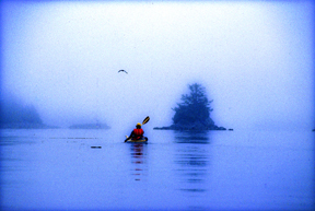
Through Dark Water, puts Phoebe on a kayaking trip to see the resident killer whales of Coastal British Columbia, Canada. When a whale turns up dead on the first day of the trip it only sets the stage for murder and mayhem on a more human scale.
Cabin on the Kane Lake Road, B.C. (2011) Photo (c) Karen Abrahamson
Last week I wrote about characters in the Canadian Cartographic past. I thought I’d continue that theme this week with an illustration of how mapping is not the objective scientific pursuit we all think it to be. Instead, mapping is an exercise influenced by politics, exploitation of resources, culture and religion. Hubris comes into play in there somewhere, too. Mapmakers influence perception through their use of scale, their level of detail and even just by what they choose to put on the map. Determining which maps are actually made is perhaps the penultimate influence on public perception.
One of the most memorable Canadian mapping ‘junkets’ involved an American millionaire by the name of Charles C. Bedaux.
In 1934 Beadaux, then living in France, initiated the Bedaux Sub-Arctic Expedition, that planned to use specially built tractors and horses to traverse, map and cut a road from Edmonton, Alberta, through northern British Columbia to the Pacific Ocean. The 1,800 kilometer route was to go through Fort St. John, Redfern Lake, Sifton Pass and Telegraph Creek. While the media reported that Bedaux claimed the expedition was purely scientific, there were other rumors abounding.
In any event, this strange expedition left Edmonton with a crew of 43 people including Bedaux’s wife, her Spanish maid, and an Italian Countess to tend to Bedaux, along with the usual accoutrements of pate de fois gras, champagne and a gamekeeper. Oh yes, and a movie cameraman to record the adventure. This was not your usual surveying venture, but along with this cavalcade of oddities, were a topnotch group of scientists and surveyors. Poor sods.
Immediately after leaving Edmonton they were caught in rainstorms that slowed their progress and caught them in muskeg, even though Bedaux’s vehicles had extra wheels that were to lift them over the worst obstacles. Bedaux had brought everything with him from French cook pans, lock and tackle to lift the tractors over vertical terrain, and claw-foot bathtubs. All the equipment literally weighed ton.
As the expedition progressed, the situation worsened. The tractors’s problems didn’t get any better and had they to be pulled out by some of the expedition’s 100 pack horses. When even this didn’t help them make better progress, he determined to start divesting himself of equipment. Not the bathtubs and champagne of course, but scientific equipment like the surveyor’s theodolite. The situation became more bizarre as Bedaux railroaded the surveyor’s assistant into becoming his houseboy, and demanded the other scientists become actors in staged moviemaking involving forest fires and staged stampedes of the horses.
Old water mill in the countryside near Besoncon, France (2004) Photo (c) Karen Abrahamson
Finally, after 14,00 kilometers, Bedaux abandoned the expedition over 400 kilometers from Telegraph Creek. Bedaux returned to France, but the meticulous maps and drawings prepared by the surveyor of the venture, one Frank Swannell, went on eight years later, to lead to the building of the Alaska Highway which followed Bedaux’s route north from Fort St. John.
And Bedaux, well his fate wasn’t quite so memorable. You see one of the rumors about Bedaux was that his venture was really a testing ground for German military transport trucks in alpine conditions. During World War II Bedaux hitched his star to the Third Reich and acted as go-between between the Germans and the Vichy French. It is suggested that he passed information to the Germans, and in 1943 he was captured in North Africa by the Americans. He was brought back to America and charged with trading with the enemy, but in 1944 he overdosed on barbiturates and died.
Thus ended another bit of Canadian cartographic history. But one wonders. Maybe we have the Germans to thank for the Alaska Highway.
Spy Lands –Who really discovered the coasts of America
Kayaking the west coast of Vancouver Island, Photo (c) Karen Abrahamson
I mentioned last week about spies and maps and government subterfuge as aspects of maps that we rarely think about. Municipal governments still fool residents with streets on maps that are planned, but haven’t been built. Map makers take liberties with place names and add imaginary towns and streets that reflect their biases for and against university football teams. But in the past spies were frequently involved in cartographic subterfuge.
For instance, most of us were schooled that Captain Cook was the first European to lay eyes on the north western coast of North America. However there is mounting evidence that the English privateer (government sanctioned pirate) Sir Francis Drake, not Cook, first saw the coast of Oregon, Washington and British Columbia between 1577 and 1580 – 160 years before Cook’s journey.
Why isn’t this known?
First of all because some historians are hard pressed to let go of old ideas, but second of all because Drake’s journey was likely suppressed and evidence of it hidden, because of disputes with the Spanish that were, later, going to erupt into war. Drake is confirmed to have travelled as far north as Mendocino, California, the farthest north the Spanish had been, but a 412 year old map commemorating Drakes circumnavigation of the globe shows details of the coast of British Columbia that no one could have known unless they had been there. Additionally, archeological evidence – 1571 British coins and equipment – have been found in Oregon and Victoria, B.C. gardens, so that Drake is believed to have travelled as far north as Prince of Wales Island in Alaska. Finally, Drake’s cousin confessed under torture to the Spanish, that a fabled North Pacific island, Nova Albion, had been discovered by Drake and claimed for England 29 years before Samuel Champlain founded Quebec and before there was a Virginia on any map. This is believed to have been Vancouver Island, kept secret.
A further example of cartographic spies, deals with those icons, Christopher Columbus and John Cabot. Columbus, we’re taught, discovered the Americas while looking for China. Cabot’s fame is due to his first North American landfall by a European. Or at least that’s what we’re taught. But in a 1498 letter that was penned just months after Cabot’s historic return from Newfoundland, a spy in England wrote to Columbus and talked about earlier voyages by men from Bristol to the same place Cabot had been and that these earlier voyages had been to an “Island of Brasil” and that Cabot’s landfall “is believed to be the mainland that the men from Bristol found”. The spy’s letter also mentions that these voyages from Bristol were well known to Columbus – something that is further supported because Columbus had spent time in Bristol and Iceland in the 1470s – almost 20 years before he managed to convince the Spanish monarchy to fund his explorations. Did Columbus use this knowledge to convince Isabella? Did he use it to calm his crew on his long crossing?
We may never know, and even if we do, will it matter? For Columbus IS an icon that history won’t forget, but what this shows is how secrets and spies permeate the European history of maps, so that who really ‘discovered’ the coasts of America may never be known. Of course, just talk to a First Nations/Native American person and they’ll tell you we’ve got it all wrong anyway. North America had been ‘discovered’ long before any European left home.
 Through Dark Water
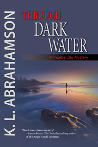
")


