Tag: Himalayas

Bhutan: Preparing for the Perilous Landscape

Bhutan: Preparing for the Perilous Landscape

Paro Dzong (fortress/monastery) in the blue light of late evening. In Bhutan these huge structures are half monastery and half government administration. Copyright, Karen Abrahamson.

Since returning home and while suffering from jet lag I’ve had a number of people ask me where I was travelling. When I answer “Bhutan” I’ve had a lot of blank stares, so just to clarify, Bhutan is a small Himalayan country pressed, geographically, between Tibetan China and India. In fact, both larger countries have, in the past, taken over parts of Bhutan, with the most recent encroachment being the Chinese moving into and claiming Bhutanese highlands. The Chinese were presumably driven by the need to claim more of the very rare and very valuable Bhutanese cordyceps—a fungus that grows out of a high-altitude caterpillar’s forehead that “purportedly has medicinal powers matched only by rhino horns, elephant tusks and tiger penises” (according to my Lonely Planet guide.)


So, Bhutan whose symbol is the thunder dragon and which enjoys a Tibetan style culture that is purely its own, sits partially in very high mountains and partially in lovely valley floors. The lowest of those valleys is apparently still higher than some of the lowest elevation cities in Peru—the last country that I visited where altitude was involved. Given how altitude sickness struck me in Peru (I couldn’t take the preventative drugs because I was technically allergic to it), I was more than a little paranoid about visiting Bhutan. The skull-shattering headaches I had in Peru made me think I might understand how the caterpillar felt when being attacked by the head fungus. So, in preparation for Bhutan, I decided to go through my own ordeal before I left on the trip. I decided to get tested to see if I really was allergic.

Cypress and fog near one of the many mountain passes. Copyright Karen Abrahamson.

The altitude sickness drug is called Diamox and it is a sulfa-based drug, to which I am allergic (according to doctors that I saw when I was sixteen years old). In the interest of seeing whether my body chemistry had changed, my current family doctor referred me to an allergist—a referral that took three months before I had an appointment, putting me only one month from my Bhutanese departure date. I arrived at the appointment and the allergist took my blood pressure, checked my heart etc., told me that I was healthy (which I knew) and then advised that there were NO tests for sulfa allergies, but if I’d like to go into the hospital for three days they could possibly test me for Penicillin allergies. (I mean what the****?) He suggested that I not take the Diamox but, as an afterthought, suggested that I might want to call the local travel clinic for a second opinion.


Given my experience in Peru and my determination to go to Bhutan, that was exactly what I did. I spoke to the travel doctor who listened to my issue. She told me to take the Diamox—there was, apparently, no cross-reactivity (whatever that means). So I did that, too.

The Himalayas as seen from Dochu La (Pass). Note the god light lighting the peaks at the end of the day. Copyright Karen Abrahamson.


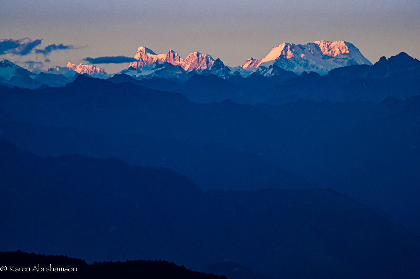
In Bhutan I travelled over passes that were 3,900 meters high and spent days at 3,300 meters—considerably higher than where I became sick in Peru (though at 3,300 meters I had frequent headaches even with the Diamox), but it was worth it. I even climbed a mountain to the Tiger’s Nest monastery at an altitude of about 3,000 meters and am here to tell the tale.


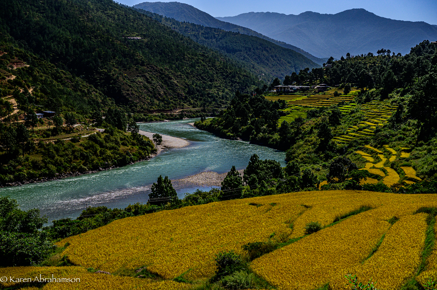
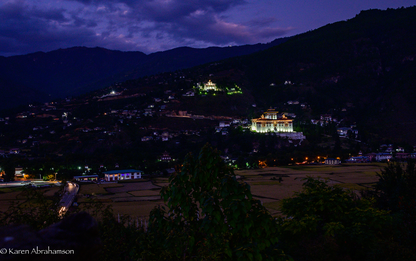
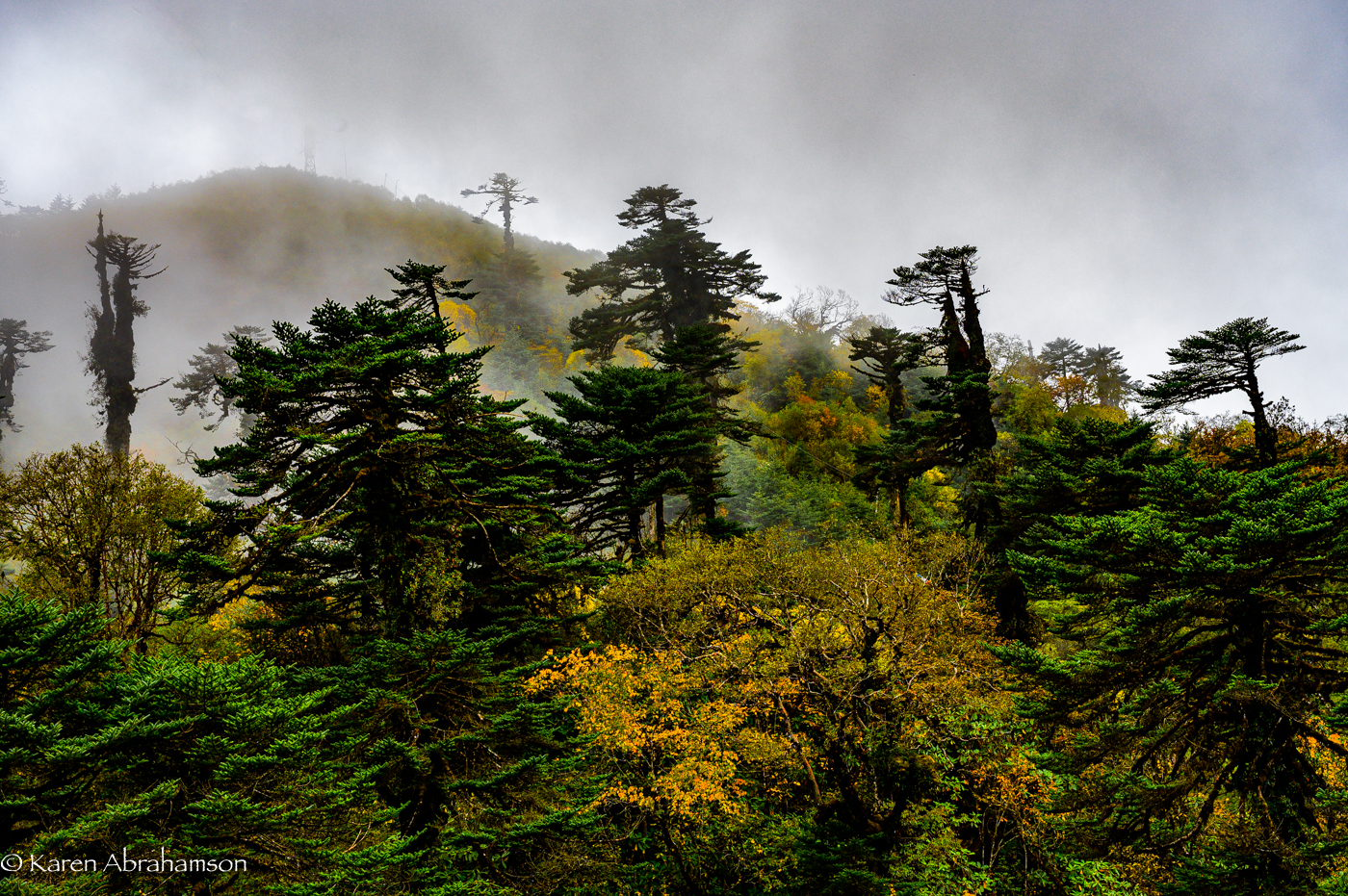
So the perilous Bhutanese landscape was really simply the magical landscape of the thunder dragon, Himalayan mountain peaks, picturesque plateaus and river valley’s so deep they looked bottomless. Everywhere there were towering cypress trees on the heights and rhododendron trees lower down. Rice fields heavy and ready to harvest lay along the valley bottoms and on stepped paddies up the valley sides. Dotting this landscape were the small towns and cities and the huge white-walled monastic fortresses called dzongs.


Most memorable of all were the beams of God-light shining through the clouds to spotlight white-washed temples or green fields. It was—supernatural, superlative, spectacular, breathtaking. And I was able to enjoy it all, thanks to the Diamox.


I pity the poor caterpillar who can’t enjoy the rarified heights where it lives.

Rice fields along one of Bhutan’s many gorgeous rivers.
Maps and Spies

Maps and Spies

Himalaya Monastery outpost (2000) Photo (c) Karen Abrahamson

In one of my last posts (here) I wrote about how Sir Francis Drake may have been the real first discoverer of the Pacific Northwest coast, and how this fact was likely kept under wraps by the British government because of the potential for Spanish spies. Maps and spies have gone hand-in-hand for years and are still important in modern battles. I recently picked up the book Swan Song and the opening scene is the President looking at spy satellite images (maps) of Russian Territory. Spies and maps. That’s what this post is about.

Of course spy satellites weren’t always around, but spies were, and they have played an important role in the Great Game of Asia (the name given to the period between 1813 and 1907 when the Brits and Russians duked it out over influence and ownership over Central Asia). Being able to map an area and to gain control over important vantage points, rivers, towns and countries was all part of ‘the game’. The Survey of India I mentioned here, was all part of the British Raj’s need to know about and control their holdings.

But they ran up against a barrier – the physical boundary of the Himalayan Mountains and the geopolitical border with Tibet that had been closed by order of the Chinese Emperor. Although Europeans had sighted the heights of K2 and had scaled peaks only slightly less tall than Mount Everest, they hadn’t been able to map Tibet because of the Chinese border that specifically excluded Europeans. As a result, a captain of the Indian Survey, Thomas G. Montgomerie, decided to train and send disguised native agents into the mountains. Only two men passed the rigorous training: cousins Nain and Mani Singh.

Himalayan Monastery along the Spiti Valley India (2000) Photo (c) Karen Abrahamson

In 1865 they went on their first mission through Nepal and into Tibet to try to reach Lhasa. The two became separated on their journey. Mani made it into western Tibet and returned with some mapping information, but it was Nain who managed to make it to Lhasa. Along the way he was robbed, but managed to retain his survey instruments. Trained to take even paces as his means of measuring distance and using a 100-bead rosary to keep track of his pace-count, he eventually entered the fabled city disguised as devout pilgrim. There he chanced public beheading by taking night-time measurements of altitude and latitude using mercury he poured into his begging bowl.

When he thought people were becoming suspicious of him, he left the city with a Ladakh caravan and headed west along the great Tibetan river, the Tsangpo. Along the way he mapped the river’s course and kept up his careful measures before finally escaping one night to make his way back across the Nepali border. He’d travelled 2,000 miles and mapped it all and returned with descriptions of Lhasa and the first reasonable placement of it on the map.

Nain’s accomplishment was followed by similar mapping parties, not all of which ended well. One agent travelled into northern Afghanistan and was murdered in his sleep. Another returned to Lhasa and back to India with data on almost 48,000 square kilometers of previously unmapped territory. A nephew of Nain’s continued the work and travelled for nearly six years in the mountains. He’d mapped a caravan route to China as well as the headwaters of the Mekon, the Salween and Irrawaddy rivers.

More impressive still, is the adventure of Kinthup, another native trained to survey the mountains. In 1880, he and another man were sent into the mountains to answer the question of whether the Tsangpo River became the Brahamputra. He braved the mountains and escaped after being sold as a slave by his ‘partner’ on the venture, but still managed to complete his mission in a feat that became legendary to Survey of India.

But it was only in 1911, after the Great Game was over, that the mapping of the Himalayas was completed, when the British joined their surveys with those of the Russians they had so long fought against. But it was brave native spies like Nain Singh and Kinthup who did the work for us and brought Lhasa and the Himalayas into the known world.

Himalayas and Crow (2000) Photo (c) Karen Abrahamson

Recent Fantasy

Available HERE,

$1.99

Available HERE,
$3.99

Available HERE $1.99


Recent Mystery


Available HERE
$4.99


Available HERE,

$4.99


Available HERE,

$4.99


Available HERE,
$4.99


Recent Romance

Available HERE, $2.99