Category: Environment

Bhutan: How to Host a Festival

Bhutan: How to Host a Festival

Gangte Goemba in full festival. Copyright Karen Abrahamson

I’ve been to festivals here in North America and elsewhere in the world. I’ve stumbled through religious and nonreligious festivities in Peru, Myanmar, Bali, Portugal and elsewhere in Europe as well as here in North America. All were colorful and all had excitement—the pageantry of a Jesus effigy led through the streets; the golden offerings of Bali; the color of Canada Day; or the raucous parties of the Fourth of July of my American friends. Not to mention the fireworks.

Dancers awaiting the Black Hat dance at Tashing Goemba, Dakar, Bhutan. Copyright, Karen Abrahamson.

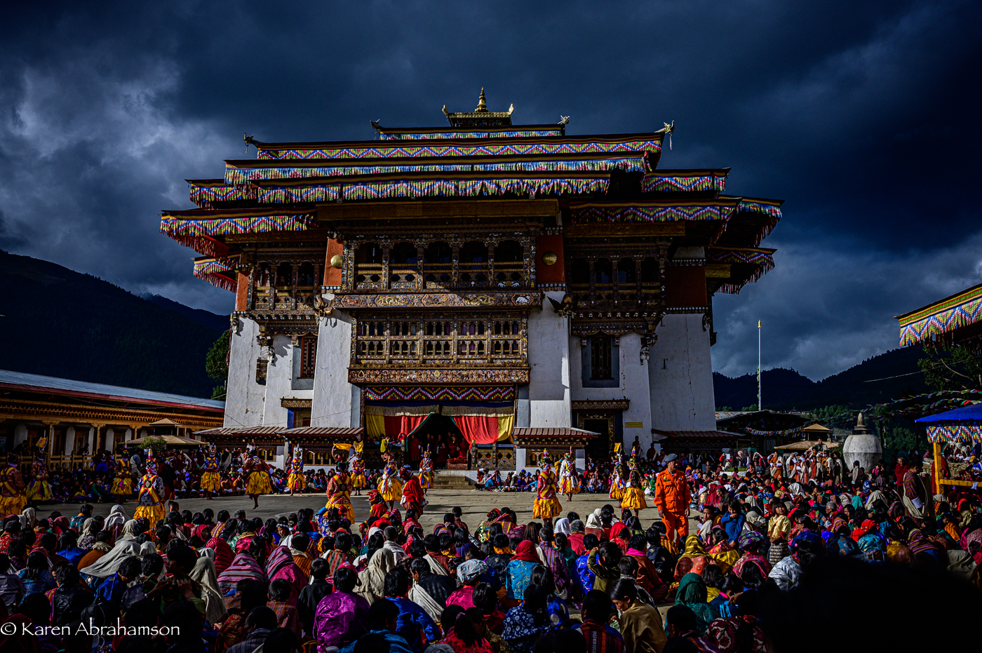
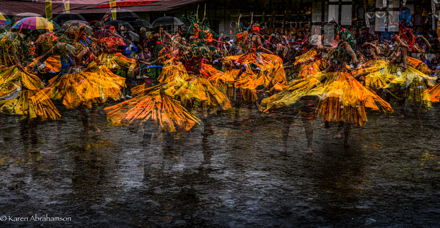
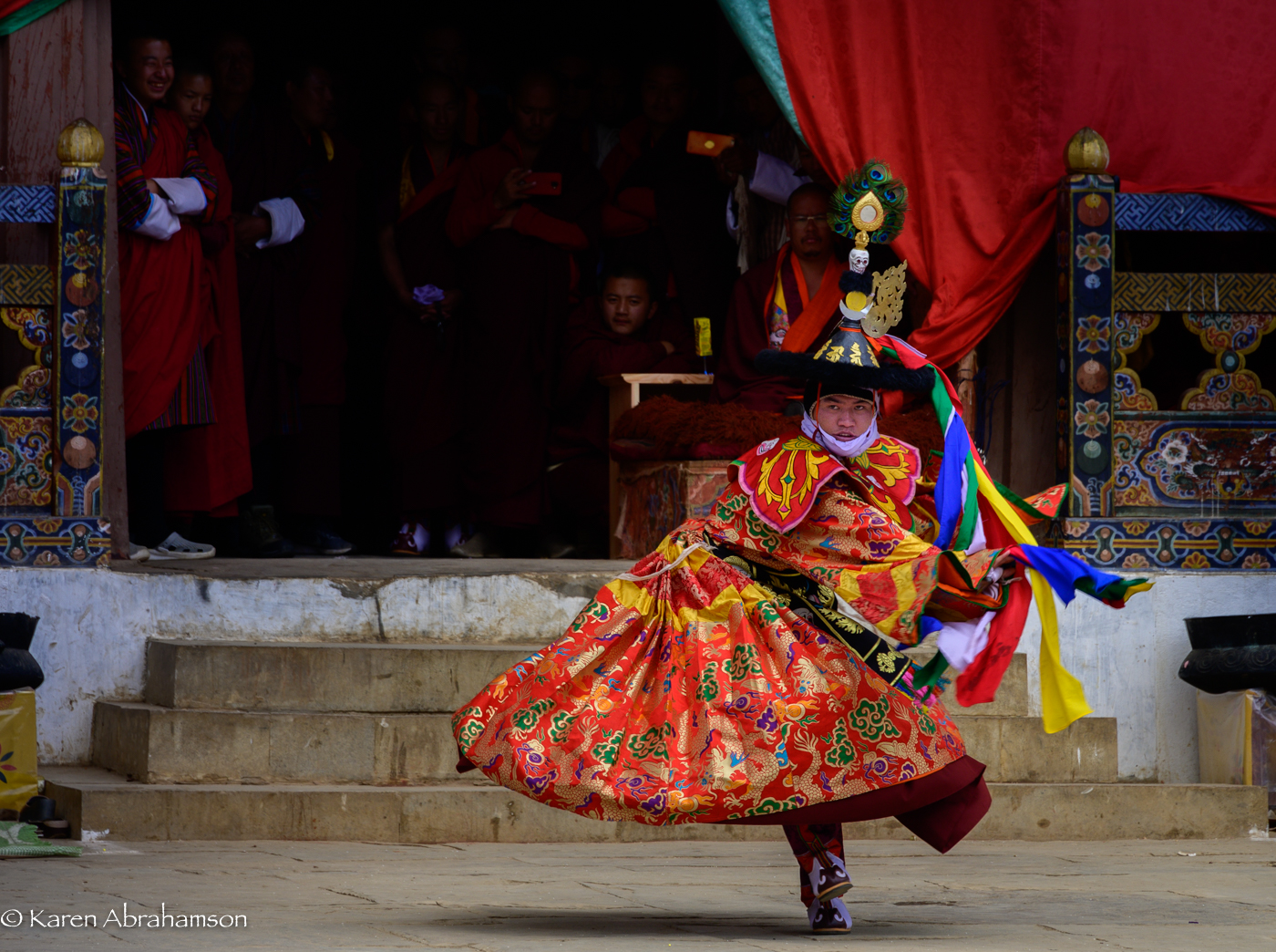
None of them have anything on Bhutanese Buddhist Monastic Festivals and I didn’t even attend the country’s biggest festivals in Thimpu or Paro, but these were the biggest, brightest, friendliest, boldest events I’ve ever been to. Think something like a major PRIDE parade on steroids.

Dancers (multiple exposure) at Tashing Goemba, Jakar, Bhutan. Copyright Karen Abrahamson.

Don’t get me wrong—there aren’t skimpily clad people running around –the Bhutanese are always chastely attired in their traditional Gho and Kira. But, well, there are plenty of phalluses. You see, because of its association with a Lama, the phallus is protective symbol in Bhutan and so you see them everywhere. Carved ones hang off the corners of homes, painted phallus adorn exterior building walls and more carved ones are set prominently above shop doors and windows. So, if you are shy of the human male member, don’t go to Bhutan. You’ll kill yourself blushing.

Bhutanese home with traditional art work. Haa Valley, Bhutan. Copyright Karen Abrahamson.

The phallus is also plenty visible at monastery festivals. Monk dancers spin around the open courtyards of these huge white strongholds, but around their edges, taunting and teasing the crowds are the ‘clowns’ (actually the most senior and best of dancers) carrying phalluses and teasing the crowds. Women and children giggle and hurry away. Men joke with these supreme joksters. At one point, one of my photographer companions was down on one knee taking a series of panning shots with his camera. The next thing he knew, he had a clown beside him, using the phallus to point as his camera, mimicking my friend’s actions. The clown got his reaction and my friend could only laugh in response.


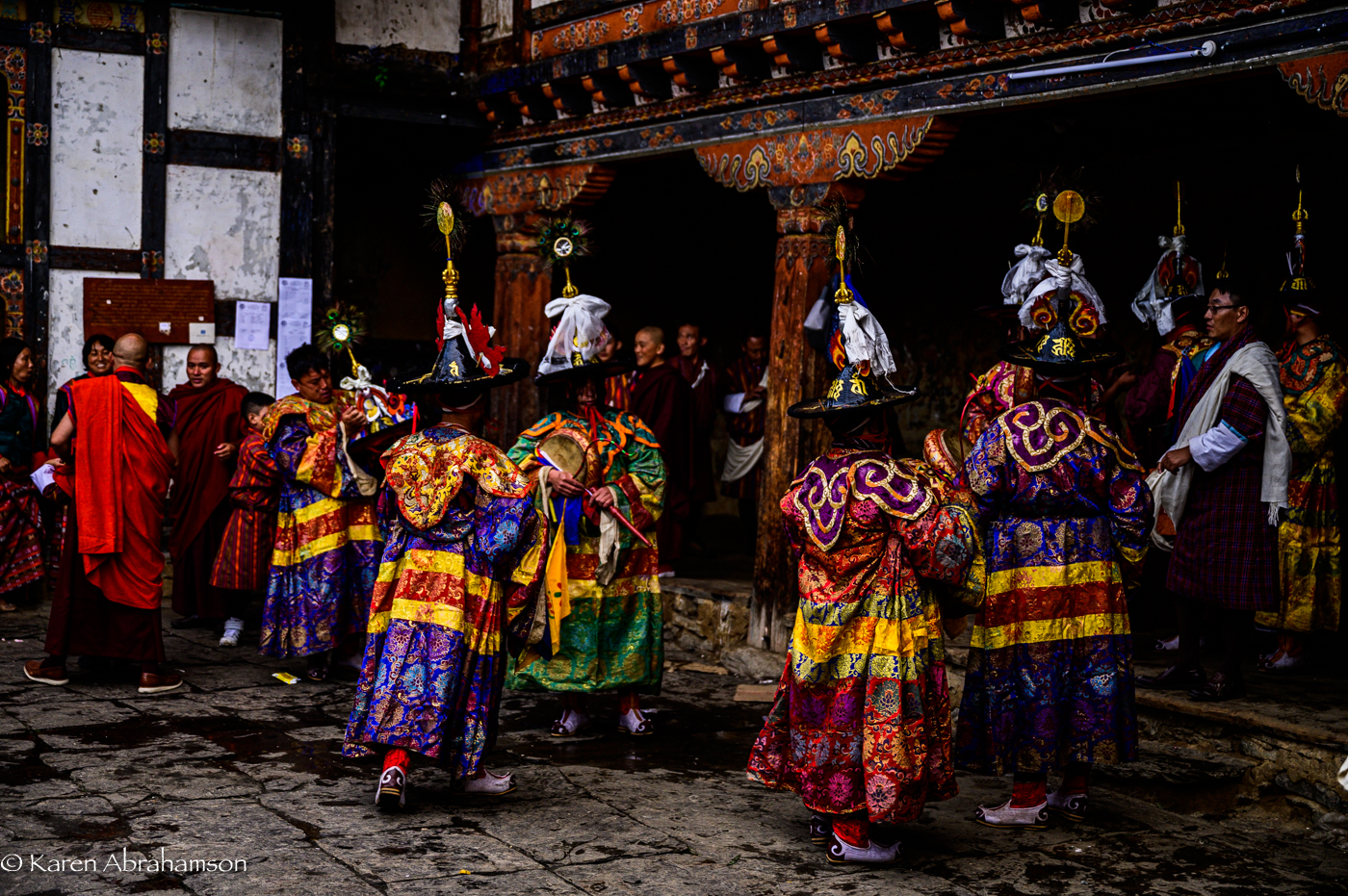
Beyond phalluses, the Bhutanese were wonderful at welcoming a motley group of photographers into their midst. Monks and local villagers usually agreed to a photo and would pose for us. At one festival we were even allowed to enter the antechamber where monks prepared for their dances and to photograph the intense preparations they went through.

Some new friends. One little girl even used my camera! Gangte Goemba, Bhutan. Copyright Karen Abrahamson.
A lovely mother and child, Gangte Goemba, Bhutan. Copyright Karen Abrahamson.

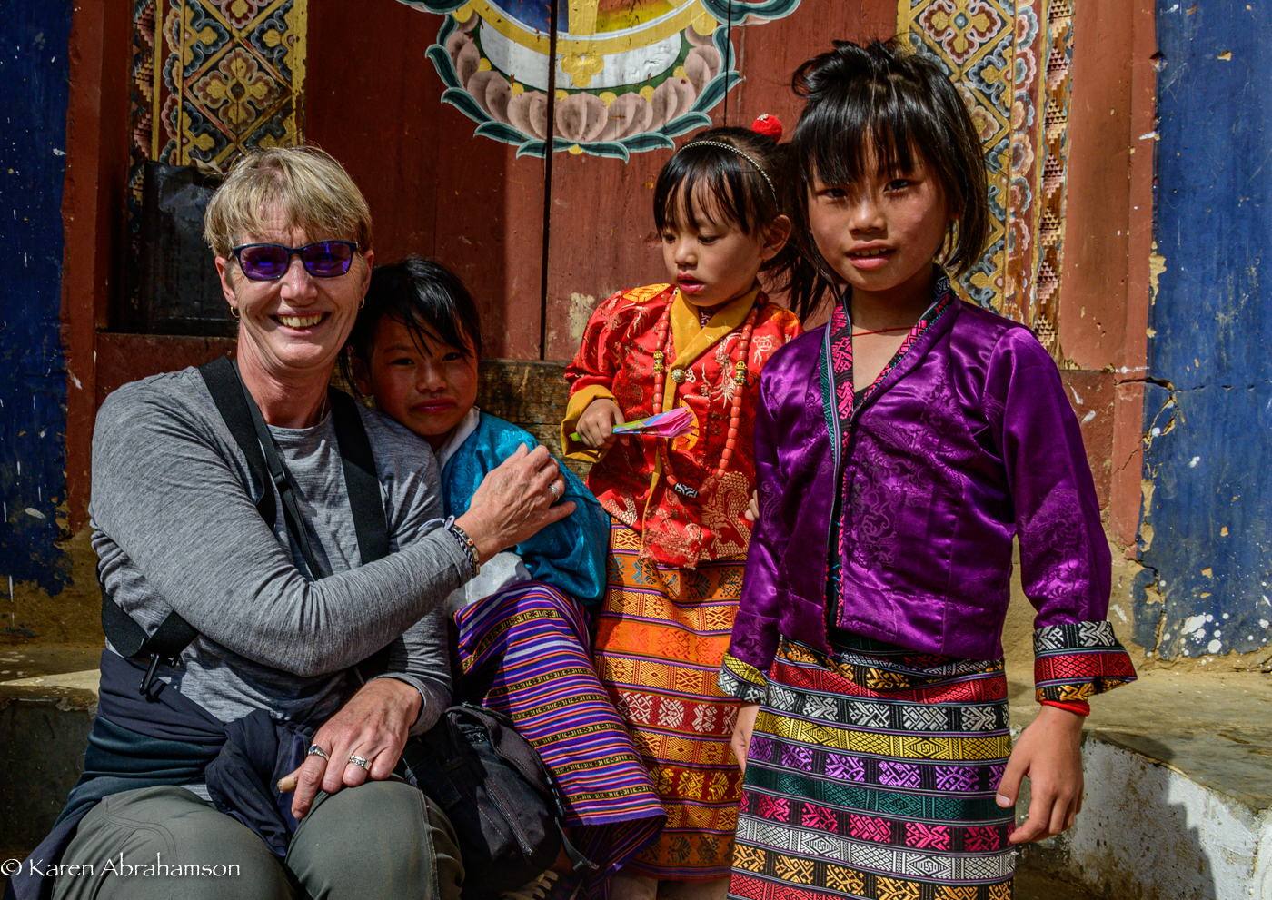
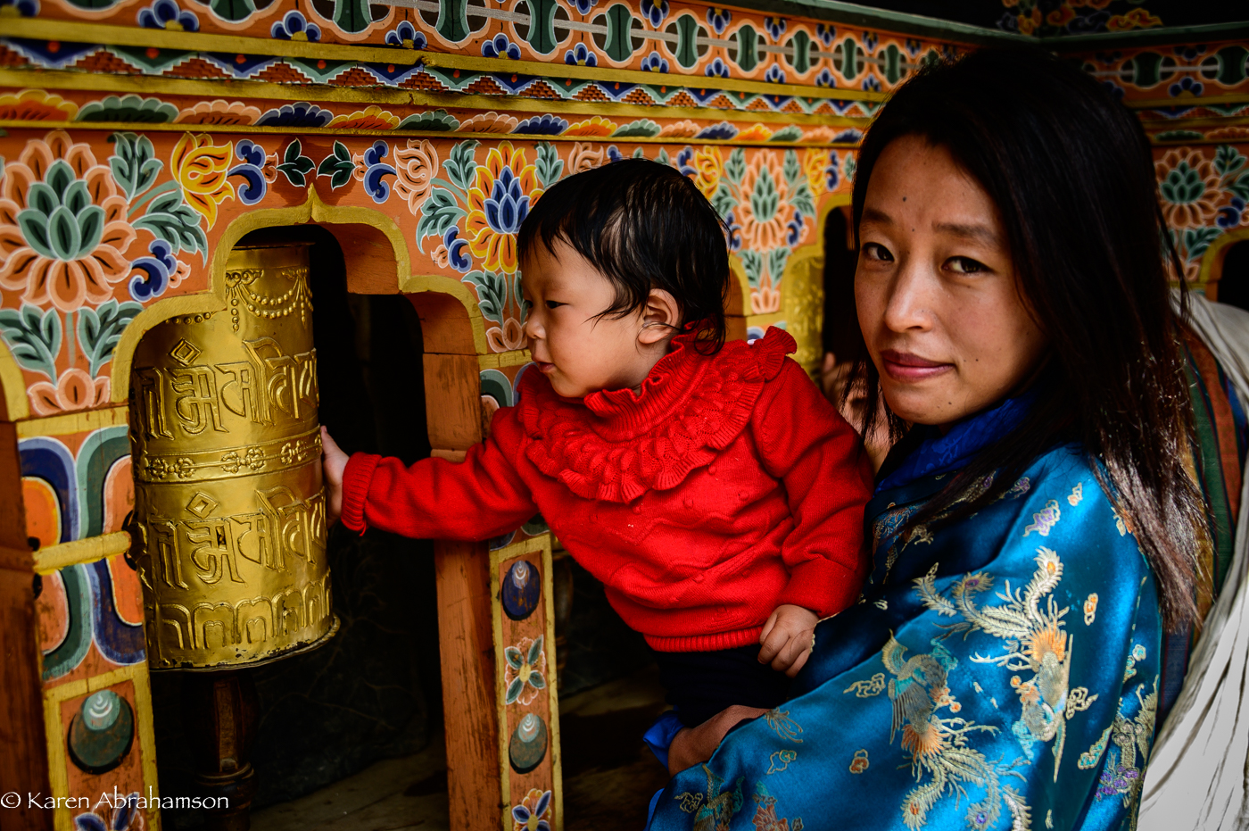
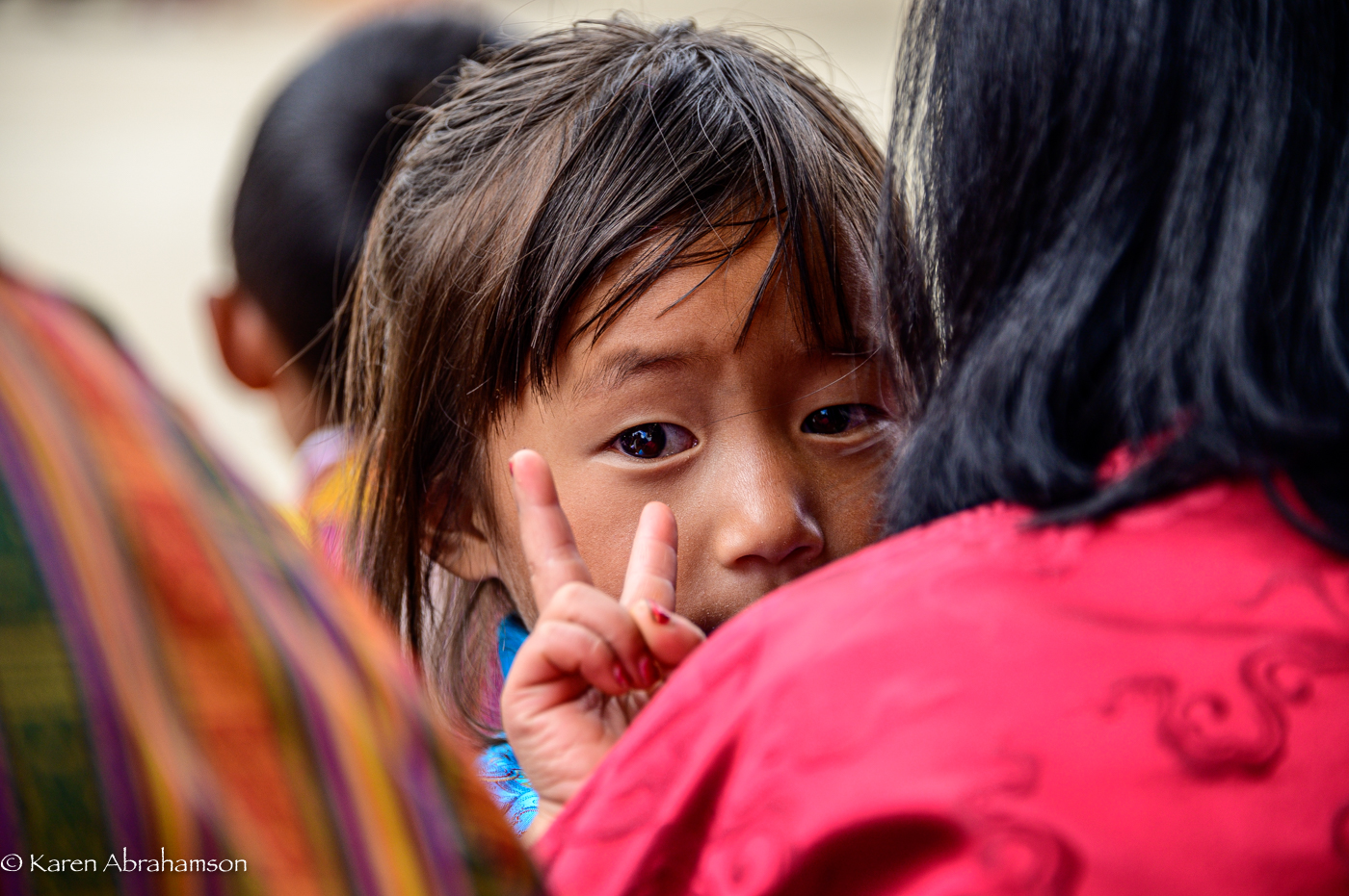
Best of all, though, were the lovely people who had come on pilgrimage to the festival and invited me to join them on their mats where they shared tea and roasted rice. Lovely and very tasty and they even tried to explain the characters of the various dances. It reminded me of other places and times and of the camaraderie of being seated on the earth and enjoying the company of the kind people you meet at festivals of this kind. It’s a chance to breathe in the spirit of a place.

Master Black Hat dancer, Gangte Goemba, Bhutan. Copyright, Karen Abrahamson.
One of my other friends at Gangte Goemba. Copyright Karen Abrahamson.


Bhutan: Preparing for the Perilous Landscape

Bhutan: Preparing for the Perilous Landscape

Paro Dzong (fortress/monastery) in the blue light of late evening. In Bhutan these huge structures are half monastery and half government administration. Copyright, Karen Abrahamson.

Since returning home and while suffering from jet lag I’ve had a number of people ask me where I was travelling. When I answer “Bhutan” I’ve had a lot of blank stares, so just to clarify, Bhutan is a small Himalayan country pressed, geographically, between Tibetan China and India. In fact, both larger countries have, in the past, taken over parts of Bhutan, with the most recent encroachment being the Chinese moving into and claiming Bhutanese highlands. The Chinese were presumably driven by the need to claim more of the very rare and very valuable Bhutanese cordyceps—a fungus that grows out of a high-altitude caterpillar’s forehead that “purportedly has medicinal powers matched only by rhino horns, elephant tusks and tiger penises” (according to my Lonely Planet guide.)


So, Bhutan whose symbol is the thunder dragon and which enjoys a Tibetan style culture that is purely its own, sits partially in very high mountains and partially in lovely valley floors. The lowest of those valleys is apparently still higher than some of the lowest elevation cities in Peru—the last country that I visited where altitude was involved. Given how altitude sickness struck me in Peru (I couldn’t take the preventative drugs because I was technically allergic to it), I was more than a little paranoid about visiting Bhutan. The skull-shattering headaches I had in Peru made me think I might understand how the caterpillar felt when being attacked by the head fungus. So, in preparation for Bhutan, I decided to go through my own ordeal before I left on the trip. I decided to get tested to see if I really was allergic.

Cypress and fog near one of the many mountain passes. Copyright Karen Abrahamson.

The altitude sickness drug is called Diamox and it is a sulfa-based drug, to which I am allergic (according to doctors that I saw when I was sixteen years old). In the interest of seeing whether my body chemistry had changed, my current family doctor referred me to an allergist—a referral that took three months before I had an appointment, putting me only one month from my Bhutanese departure date. I arrived at the appointment and the allergist took my blood pressure, checked my heart etc., told me that I was healthy (which I knew) and then advised that there were NO tests for sulfa allergies, but if I’d like to go into the hospital for three days they could possibly test me for Penicillin allergies. (I mean what the****?) He suggested that I not take the Diamox but, as an afterthought, suggested that I might want to call the local travel clinic for a second opinion.


Given my experience in Peru and my determination to go to Bhutan, that was exactly what I did. I spoke to the travel doctor who listened to my issue. She told me to take the Diamox—there was, apparently, no cross-reactivity (whatever that means). So I did that, too.

The Himalayas as seen from Dochu La (Pass). Note the god light lighting the peaks at the end of the day. Copyright Karen Abrahamson.


In Bhutan I travelled over passes that were 3,900 meters high and spent days at 3,300 meters—considerably higher than where I became sick in Peru (though at 3,300 meters I had frequent headaches even with the Diamox), but it was worth it. I even climbed a mountain to the Tiger’s Nest monastery at an altitude of about 3,000 meters and am here to tell the tale.


So the perilous Bhutanese landscape was really simply the magical landscape of the thunder dragon, Himalayan mountain peaks, picturesque plateaus and river valley’s so deep they looked bottomless. Everywhere there were towering cypress trees on the heights and rhododendron trees lower down. Rice fields heavy and ready to harvest lay along the valley bottoms and on stepped paddies up the valley sides. Dotting this landscape were the small towns and cities and the huge white-walled monastic fortresses called dzongs.


Most memorable of all were the beams of God-light shining through the clouds to spotlight white-washed temples or green fields. It was—supernatural, superlative, spectacular, breathtaking. And I was able to enjoy it all, thanks to the Diamox.


I pity the poor caterpillar who can’t enjoy the rarified heights where it lives.

Rice fields along one of Bhutan’s many gorgeous rivers.
What is a Picture Worth?

What is a Picture Worth?

You see photographs on Facebook and other Social Media all the time, but I’ve never been particularly prolific in this respect. I’ve decided to change this because with changes in life circumstances I’m getting more chance to become friends with my camera. Don’t get me wrong, I’ve always enjoyed photography, but now I’m getting more serious and will be posting images from areas around where I live, and from my travels.

For example, here are a few shots from a kayaking trip I took this summer in the Broken Islands of B.C. for those of you who don’t know them, here’s a great article on them. They are a spectacular archipelago of tiny islands with shell beaches, lagoons, tiny coves and channels between them and moss laden tree branches that shadow the water.

Here are a few shots to give you the flavour of them. Cheers!

copyright@ Karen Abrahamson
Copyright @ Karen Abrahamson
Copyright@ Karen Abrahamson
Copyright@ Karen L. Abrahamson


The Care and Feeding of Birds… and Novels

The Care and Feeding of Birds… and Novels

I put up a new birdfeeder the other day. It’s not the feeder oriented toward small birds like rosy and gold finches or chickadees. This one is solid wood, with a solid tray and a wooden roof that I inherited from my parents’ house. I decided to throw it up on my back deck as a way to get rid of some bird feed that I had had left at my house.

The first day a few little birds fluttered over from my other feeder to try it out. This carried on for a few days, but they clearly preferred my tube feeder with the chopped sunflower seed. I waited anxiously to see whether anyone would like the plain bird seed, peanuts and sunflower seeds in their shells. About three days in suddenly I had a vivid blue visitor—a cocky Stellar Jay. Not long afterwards there was a second—a youngster who kept bugging his mother to feed him even though he was perfectly capable of feeding himself. These two kept the feeder busy, taking turns feeding and teasing my Bengal cats in the process.

Two weeks later the population of Stellar Jays has doubled with four of the forward little fellows coming in to feed. They also take great pleasure in teasing the cats by hopping right up to my sliding screen doors. There are also two or three flickers that come in to feed as well as the usual mix of smaller birds. It’s kitty T.V.

The process of building a population of bird neighbors got me thinking about the care and feeding of novels—mainly because this spring and summer life has kept me from being able to write as much as I would like to. It got me thinking about how the kernel of an idea for a novel is a lot like putting out a birdfeeder.

Writing a novel requires the same faith as putting up that bird feeder, but instead of waiting for the birds, as a writer I’m waiting for the visitations of ideas. When I first put fingers to keyboards to start a new novel, it’s like hanging out the birdfeeder. There are tempting ideas there, there may even be ideas about the characters you intend to include, but the reality is something else. The core of the idea is there, but finding the other ideas that make a novel a novel is another matter altogether. After all, a bird feeder without birds isn’t much of anything at all and a novel without layers of ideas is at most a short story.

In the best of cases, new ideas come as you write. They really do seem to flutter down of their own accord, attracted by your initial idea—some even strut onstage cockily much like a Stellar Jay. The best of them you never see coming, leading to a veritable Eureka moment. The ideas that surprise the writer are my favorite kind and are usually the situations or reversals of fortunes that please readers the most, too. They are the ideas I strive to find in my stories, but in truth I think the ideas find me.

This year my creative process seems to have been dampened by dealing with too many family issues. It feels like my bird feeder is empty. And yet…

I wrote a short story the other day (good or bad, who knows) and I saw a pileated woodpecker for the first time since I moved into this home 18 months ago. My plan for this challenging time is to gradually get back into writing and to blog about the process.

And I will remember my bird feeder metaphor. If I start the novel, the big ideas will come.

Wish me luck.

Inspiration and a new Short Story

Inspiration and a new Short Story

I’m pleased to announce the publication of a romance novella called ‘The Rescue’. The story is based loosely on the fact that I broke my leg in January just like Amanda did in the story. The difference was, I fell on ice, not wet wood and I never had a handsome search and rescue man come and rescue me. Sigh.

I had to walk out.

I hope you enjoy the story. Here is the blurb:

The Rescue, by Karen L. McKee

Amanda Ripper escaped a controlling husband who convinced her that she was weak and an invalid. To convince herself that it wasn’t true, she fills her life with friends and hiking and refuses to become involved with anyone again. Then she falls and breaks her leg, reigniting the specter of her old life. Can a handsome man from search and rescue to give Amanda a chance at life again?

Available on Amazon, Smashwords and Kobo.

Road Maps and Avarice

Road Maps and Avarice

Uigher apothecary shop, Kashgar, Western China. I doubt this shop still stands as the Chinese have torn most of the old city down for new ‘Chinese’ development. (1997) Photo (c) Karen Abrahamson.

Yes, it is all about the money.

Two weeks ago I wrote about the Klondike gold rush and how that led to cartographic oddities that misled gold seekers into taking ill-advised routes to the gold rush. But other maps are also intended to ‘sell’ to their users—including the ubiquitous road map.

Americans often claim that they invented the road map, and indeed Americans certainly created the most extensive collection of roadmaps just as they advanced their road systems. But there are earlier versions of roadmaps. In the third century the Romans produced a six meter-long map of roads and distances between certain points called the Peutinger Table (now stored in a Viennese museum) and during the time of the crusades crude journal/maps of routes to the Holy Land were produced. But the modern road map is largely an American invention.

These maps didn’t originate with cars in mind, but as a result of bicycle clubs in the late 1800s when cyclists were searching for maps of paved roads to enjoy their activity. Cars soon took over and road maps developed as promotional tools to encourage people to travel to, and live in, new places. Of course, as new locations opened up, land sales increased, and as the car culture grew and people travelled more, road maps did wonders for the bottom line of the oil companies.

A Peruvian cowboy in the Sacred Valley. These roads still resist development. (2011) Photo (c) Karen Abrahamson

But maps were used for promotion by other companies, too. In Canada, department stores developed road maps that showed that ‘all roads started or ended’ on Yonge Street, Toronto, the location of their store. Maps produced by oil companies specifically marked the location of oil refineries and invited people to visit these new ultramodern facilities. Maps produced by exhibitions/fairs included images of vehicles speeding to that location. Road maps were not just a means to open up a person’s eyes to the many places in the landscape, they were a means to direct that person’s attention to a specific location in an overt attempt to separate that person from their money.

City maps were more of the same only concentrated in a microcosm of what was going on all over the United States. John Jacob Ast0r became the veritable poster child for land speculation through his exploits in Manhattan. Astor bought his first lot on the Lower East Side in 1800 and gobbled up numerous lots afterwards to make a fortune in property values. What was bought for$50 an acre in 1800, was worth $1,500 in 1920 and as the City’s grid system was planned well before the city finally took shape, Astor was able to parlay his wealth into $25 million—the wealthiest man in America when he died in 1848. How did he do that? By looking at the street map of the city. Then he could sell properties—always at a profit—to take the cash and purchase more property in as-yet undeveloped areas that would be worth even more in the future. For example, a sale at $12,000 allowed him to purchase lots that would be worth $80,000 in a few short years. All because the road maps, like the maps to the Klondike, told him where to go.

Which brings me to the latest development debacle in Greater Vancouver: a developer not only leveled all the trees on the property that was soon to hold four mega houses, he also leveled the trees in a local park, on private property and along a salmon spawning stream. I’m not holding my breath given the history of cutting down trees in these parts, but here’s hoping a large part of his profits go into reparation.

Mist over the Fraser River. These peaceful scenes are ending as hihg-density development occurs. (2010) Photo (c) Karen Abrahamson


Maps, Klondike Gold and Northern Pipelines

Maps, Klondike Gold and Northern Pipelines

One of the Kane Lakes, Central British Columbia (2012) Photo (c) Karen Abrahamson

I’ve mentioned previously how maps are actually an argument on paper to convey, or propagate, a specific belief system. A good example of this was seen in the late 1800s during the famed Klondike Gold Rush that lured many a man (and woman) north to what was then viewed as the last frontier on the continent.

In the early 1880s little was known of the geography and geological wealth of the north but, extrapolating from gold strikes in places like Cassiar, British Columbia, there were rumors abounding of what might be found. As a result of the lack of real information, the Geological Survey of Canada sent surveyors north and by 1887 a report, with maps, had been completed that outlined the territory’s geological features and mining prospects as well as its geographical features. The report went so far as to predict gold finds in the Yukon and in 1896 that came true, with the discovery of placer gold on Rabbit Creek.

The resulting gold rush led to a demand for maps of the area. When the Geological Survey ran out of official maps, private companies and cities and towns took over. All of them wanted their piece of the Klondike pie, so many cities and private operators developed maps of the Klondike that presented their city, or their route as the best-easiest-most direct (you choose which) way to get to the north. They couldn’t all be right, so of course, they lied or at least doctored the truth to be in their favor.

Old farmstead, Yukon (2009) Photo (c) Karen Abrahamson

Case in point were maps that gave the impression it was only two or three days from Edmonton to the Klondike, because the prospector just had to navigate two waterways and they would arrive at their destination. Other maps skewed the projection of the earth (a projection is used to take the landforms of a round earth and place them on a flat map. Every projection skews the land formations to some degree, but different projections can be used to make different part of the land look larger or smaller). These new maps emphasized the huge distances of some routes and made others look shorter. Of course they also failed to mention things like mountain barriers or the high costs associated with steamer passage across lakes that blocked the short way to the promised land.

Which brings me back once more to the Northern Gateway Pipeline. While Enbridge and the Canadian Government show maps of the pipeline route and claim that it will be built to withstand the rigors of northern British Columbia and will pose limited risk to the landscape, the fact is that they haven’t even allowed a full environmental assessment of the area the pipeline proposes to cross. The trouble is, we’re unlikely to ever have such an assessment, because the Canadian Government has failed to provide its scientists with the resources (time, staff, funding) to complete such an assessment within the time the Government’s process now allots.

As a result the rhetoric on safety and responsibility we’re hearing from the Canadian Government sounds an awful lot like the maps to the Klondike from Edmonton. A road trip of two to three days of easy travel.

Right. And we’re supposed to believe it.

The government seems to be hoping that, just like gold on the Klondike did to prospectors, black gold to be sold to China will inflame our imaginations and distort our knowledge of geography – and make us believe anything.

Not going to happen, Mr. Prime Minister.

Old homestead, Yukon (2009) Photo (c) Karen Abrahamson


Mystical Dunvegan and the Northern Gateway Pipeline

Mystical Dunvegan and the Northern Gateway Pipeline

Along Kane Lake Road, British Columbia (2012) Photo (c) Karen Abrahamson

The furor in British Columbia about the proposed Northern Gateway Pipeline got a little bit more interesting this past week. First of all we had Enbridge providing the public with maps of the coastal route to be used by oil tankers. Those maps conveniently left out all the islands and difficult narrow ocean channels those same tankers would have to navigate. Then we had the announcement by a B.C. newspaper mogul that he was exploring the potential for building an oil refinery on the Northwest coast of BC. His rationale was that with so many people concerned about oil tankers travelling the treacherous and pristine British Columbia waterways, why not process the oil in BC, create new jobs, and only ship processed gas and diesel. This would alleviate some of the concerns over a potential oil spill as both gasoline and diesel are easier to clean up and don’t pollute like oil does. Of course the reaction has been mixed. Even the oil companies aren’t sure they like his alternative, but Enbridge’s maps and the newspaper mogul’s vision put me in mind of the ‘town’ of Dunvegan.

Abandoned Yukon Homestead (2009) Photo (c) Karen Abrahamson

I say ‘town’ with parentheses because Dunvegan was never actually built, but in the saga of Canadian maps it has a place of ignominy. You see, as the Dominion of Canada was busily surveying and dividing the country to encourage development it led to a boom in land speculation. These high stakes games were trying to anticipate where the next great land boom was going to take place. Dunvegan seemed like a likely place.

Located six hundred and fifty kilometers north of Edmonton, Alberta, Dunvegan was a convergence point for a number of native trails and a regular route for explorers and map makers. Indians camped there. Two creeks met there. A fort was built at the location and provided a jumping off point and point of safety for missionaries, explorers and homesteaders. Dunvegan became one of those mystical places on the map like Finisterre was to the pilgrims on the Camino de Santiago in Spain and France.

So much did Dunvegan enter the public consciousness of the day that it was included in the name of the first railroad to the Peace River in British Columbia, the Edmonton-Dunvegan and British Columbia Railroad. The trouble was, the railway never actually ran to Dunvegan. This was never mentioned in all the real estate material selling land to Englishmen and Easterners. Nope, the material and the maps showed the rail running to the town. Along with the railway the maps showed wharves along the waterways and development. But that wasn’t the only problem with Dunvegan. The many maps of the town being used to sell the land to the unwary, showed quarter sections of land without bothering to mention the topography. Think vertical cliffs and steep drops. Though the land was sold to many, not one lot was built upon because of the many difficulties.

Kayaking Clayoquot Sound, British Columbia (1996) Photo Karen Abrahamson

Which brings me back to the proposal for a pipeline and a world class oil refinery on the north coast of British Columbia. Sure, you could build the refinery, or you can talk about it, but such a refinery is dependent upon a pipeline across the same type of terrain that turned back the land investors in Dunvegan. I like to think that unlike the unsuspecting purchasers of land in Dunvegan, the British Columbia public won’t be taken in by maps and rhetoric that enhance non-existent amenities and that minimize the dangers that do.


The Past, the Future and Map Wars

The Past, the Future and Map Wars

Dhow off Zanzibar Island (1994) Photo (c) Karen Abrahamson

I’ve written about how maps created belief systems in the people of old. In ancient days, stories and maps of Prestor John led people to Asia and Africa in search of his kingdom. Mariners believed that the Indian Ocean was a huge inland sea surrounded by Africa that swept down and around to join with Asia. When North America was discovered, maps of the mythical Northwest Passage, led explorers to seek the real passage. But maps do more than that. Maps are sources of propaganda and maps are sources of conflict. You see maps, their systems, omissions and scale (as examples) are often used to take forward propaganda or a dominant world view. They have been used this way close to home in Canada.

For example, for many years maps of Lake Superior were left largely blank, because people believed the lake was very deep. But the truth was that fishermen didn’t want their secret ‘fishing shoals’ mapped for others to find. It was only after military vessels went missing (not to mention the Edmund Fitzgerald) that in 1930 that the Canadian Hydrological survey confirmed that there is a mountain rising in the middle of Lake Superior creating a large shoal. This shoal had been known to American fishermen, but no one had ‘told’ because the area was a magnet for fish.

Recent visitors. (2012) Photo (c) Karen Abrahamson

Maps as propaganda were used extensively in the settling of Canada. The Dominion of Canada turned surveyors maps of soil and rivers into grid maps that were then artistically enhanced with pastoral images of farms and young golden-haired women clad in white dresses. Atlases of Canada were created and sent to Europe and America in hopes of encouraging immigration. The art was focused on meeting the pastoral desires of the Europeans and in particular the British. Slightly different art work was used for maps sent to America. It didn’t matter that the images didn’t reflect the prairie landscape (The images were more of Ontario). It was the dream of the pastoral lifestyle that drew the immigrants that Canada needed.

These same maps with their grid lines were sources of conflict because they established expectations about how people would inhabit the landscape. The grids were set out in sections six miles by six miles, based on latitude and longitude, regardless of the lakes or waterways they crossed. As I mentioned in a previous blog (here) the Metis found the grid pattern foreign because they settled land based on long strips of land that swept back from water courses and that allowed everyone access to water. But immigrant groups from Eastern Europe also had challenges with the grid pattern. They were familiar with more communal, village styles of land allotment, where the land was marked off from the village in a manner more appropriate to communal living. As a result these groups (the Mennonite, Doukhobors, and Hutterites) subverted the grid style by purchasing the land, but then subdividing it according to what worked for them.

Kayaking the coast of British Columbia (1996) Photo (c) Karen Abrahamson

Maps were also used as propaganda by commercial entities such as the railroads. Canada’s two railways, Canadian Northern (CN) and Canadian Pacific Railway (CPR) battled for ridership through their maps. Maps were developed that left out or diminished the competitor’s railway. For example, CN created a triangle route map between Edmonton, Jasper National Park and Vancouver that played with scale. In this map CN’s journey through scenic Jasper was presented in large scale so that the route through Jasper leaves little room for any other details, while the rest of British Columbia was presented in small scale that didn’t allow CPR’s rail lines to even exist—according to the map. The interesting thing about this map is that no one then, or even today, notices the scale issues with the map—we accept what the map presents as reality.

So while maps are supposed to be presentations of reality, the big question the map reader has to ask themselves is whose reality (or wishful thinking) are they reading. Sometimes it is helpful to step back from the map and ask what does this map tell up about the people who developed (or paid for) it? Or what was going on at the time it was made? Or Why was this map even made? I think of my local community developers who, like the Dominion of Canada with their maps, are presenting the paved-over reality they would like to have made. The question is whether this is the map of the future we want, or whether, like the Mennonites, Hutterites and Doukhobors, we can  subvert it to a better reality.

Maps, Childhood, Disease and Living Bridges

Maps, Childhood, Disease and Living Bridges

One of the Kane Lakes, Central British Columbia (2012) Photo (c) Karen Abrahamson

Two weeks ago I wrote about the rampant development planned in one of the cities here in the Lower Mainland in British Columbia. They plan to ‘develop’ most of the large wooded acreages remaining in the city into high density housing developments, that, if they are anything like the other development in the city, will strip all trees from the landscape. When I questioned that decision I was told that the land was just too expensive to keep in forest. This week I’m questioning that decision.

You see there is increasing evidence that contact with nature has profound effects on both adults and children, with the impact even greater for children. For example, research indicates that children with attention deficit are better able to concentrate after contact with nature. Children who regularly play in a natural environment have better motor skills and are sick less often. The diverse play opportunities of the natural environment leads to increased collaboration and improved language skills. Outdoor environments are important to children’s development of independence and autonomy. And these are just a few of the developmental benefits of nature for our children.

Doing what kids do. The nieces at Buntzen Lake. (2011) Photo (c) Karen Abrahamson

At the same time, we are seeing the development of what some researchers are calling a ‘childhood of imprisonment’ as opportunities for play in natural surroundings are being paved over and built upon and parents become so concerned about their children’s safety outdoors that play outside has virtually disappeared. Locally we see this with the proliferation of townhouses intended for young families being built with no yards, so that children are forced to play inside, unless a parent is willing to take children whatever distance it takes to get to a park.

If you don’t care about child development, other research (and maps) speaks to the impact of the destruction of natural habitat on the incidence of disease. A recent article in the New York Times pointed out that hot spots of emerging diseases and potential pandemics are where deforestation is occurring. As an example, researchers point out that a 4% increase in deforestation led to a 50% increase in malaria in some parts of the Amazon basin. Closer to home, North American deforestation has led to the increased spread of diseases like West Nile Virus and Lyme Disease, that are spread by robins and mice respectively. In both these cases, the replacement of forest with habitation of agricultural fields, tipped an ecological balance that favored animals and birds without their usual predators. This link takes you to an interesting map that shows that hot spots don’t just abound in other parts of the world. In North American areas of greatest risk exist around most of our largest urban centers—including here in British Columbia.

Jo at Okanagan Lake (2011) Photo (c) Karen Abrahamson.

Today’s children live lives far different from what my generation enjoyed when we could go play down the block, in the park, and even in the woods. It used to be that during the summer children escaped outside to play in the fields or the local creek or the woods. Sometimes it was a vigorous game of tag. Other times we sought treasure with our homemade maps. Now children’s indoor lives have them living in a world that is dominated by media. Not only is this a loss for the children, but it is a loss for nature, because children raised without contact with nature and animals will have less reason to care about the natural world. Children’s experience of nature is being limited to T.V. programs like National Geographic and they are growing up thinking that nature is exotic and not learning that nature is right outside their door and that they must care for it.

This should concern all of us, for raising our children away from nature, means that we are separating them from a large part of who and what they are and stealing their access to an important natural legacy. Humans might think they are above, and can control, the environment, but as we see the impact of climate change wreaking havoc across America and the world, perhaps we need to rethink our strong-arm approach dealing with the coming disaster, and instead turn our minds to a more conciliatory approach to nature. It has been done before. As this lovely video about the living bridges of Northeastern India show, sometimes nature provides its own answer to a problem, if we can just value nature enough to listen and hear.

The Living Bridge


Recent Fantasy

Available HERE,

$1.99

Available HERE,
$3.99

Available HERE $1.99


Recent Mystery


Available HERE
$4.99


Available HERE,

$4.99


Available HERE,

$4.99


Available HERE,
$4.99


Recent Romance

Available HERE, $2.99