Tag: risk taking

Lost in Bali

Lost in Bali

At one of our guesthouses. Photo copyright Karen Abrahamson.

We’ve been in Bali ten days now and it has been a wonderful lesson in exploration—both sensory and experiential. For instance, at the moment I’m in my bed listening to a thundering downpour and the quintessential sound of gamelan music played for a Balinese shadow puppet show.

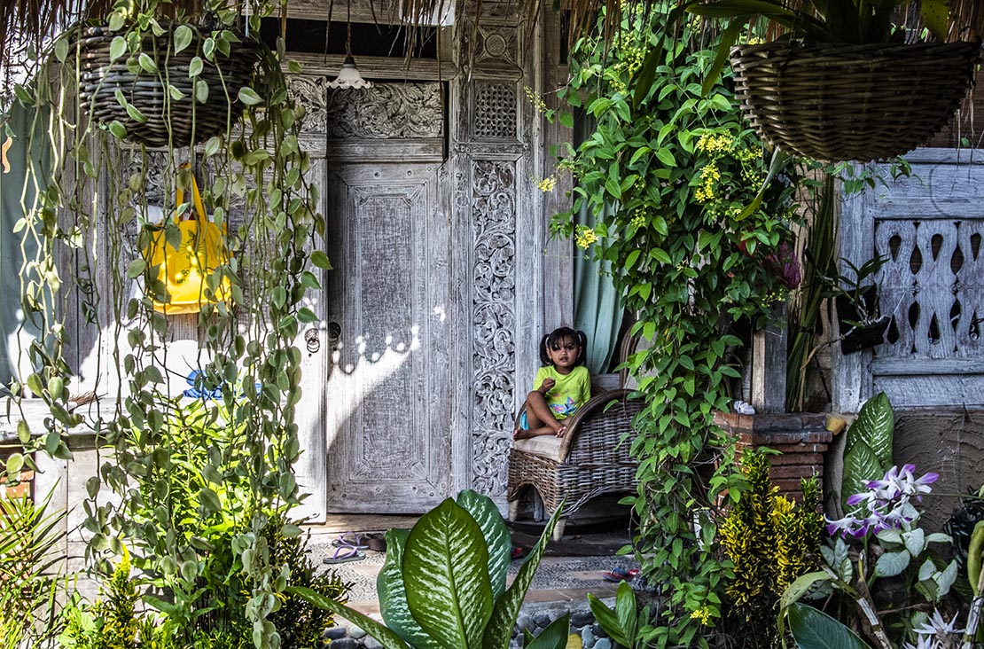
But not every experience has been quite so mesmerizing. At least they haven’t all been quite so easy to enjoy. Take for instance my first experience at my current guesthouse in the tourist mecca of Ubud. Ubud sits on the lower slopes of Bali’s central mountains and is a mecca for artists from around the world. Think wood and stone carving, silver smithing, weaving, painting and just about anything else you can imagine. We arrived at this guesthouse and our host knew of my interest in photography, so he immediately told me that there was a temple ceremony occurring that afternoon at a local community—come see him at three pm and he’d arrange for me to attend.

I showed up with camera in tow and the only way to get there was via motorcycle—him driving and me on the back. Let me just say that my distrust of motorcycles goes way back to my teenaged years and age and wisdom has only confirmed that opinion.

The temple musicians waiting for the ceremony to finish. Photo copyright Karen Abrahamson.

But it was a temple ceremony and I was new to Ubud. Who knew whether I’d get such a chance again. So I slung my leg over the motorbike behind him and drove—sans helmet because he didn’t want to have to carry an extra helmet back—to somewhere in Bali.

And he dropped me off.

Yes, I had his email and phone number on Whatsapp. Yes, I knew the name of the guesthouse and generally where it was in Ubud. But that was all. And oh, yes, I know how to say hello and thank you in Balinese.

But there was this temple ceremony, that it turned out I couldn’t attend because I didn’t have a proper sarong…

Youngsters mesmerized by the musical instruments and the fathers trying to keep them in tow. Photo copyright Karen Abrahamson.
The ceremony gates. So close, yet so far. Photo copyright Karen Abrahamson.

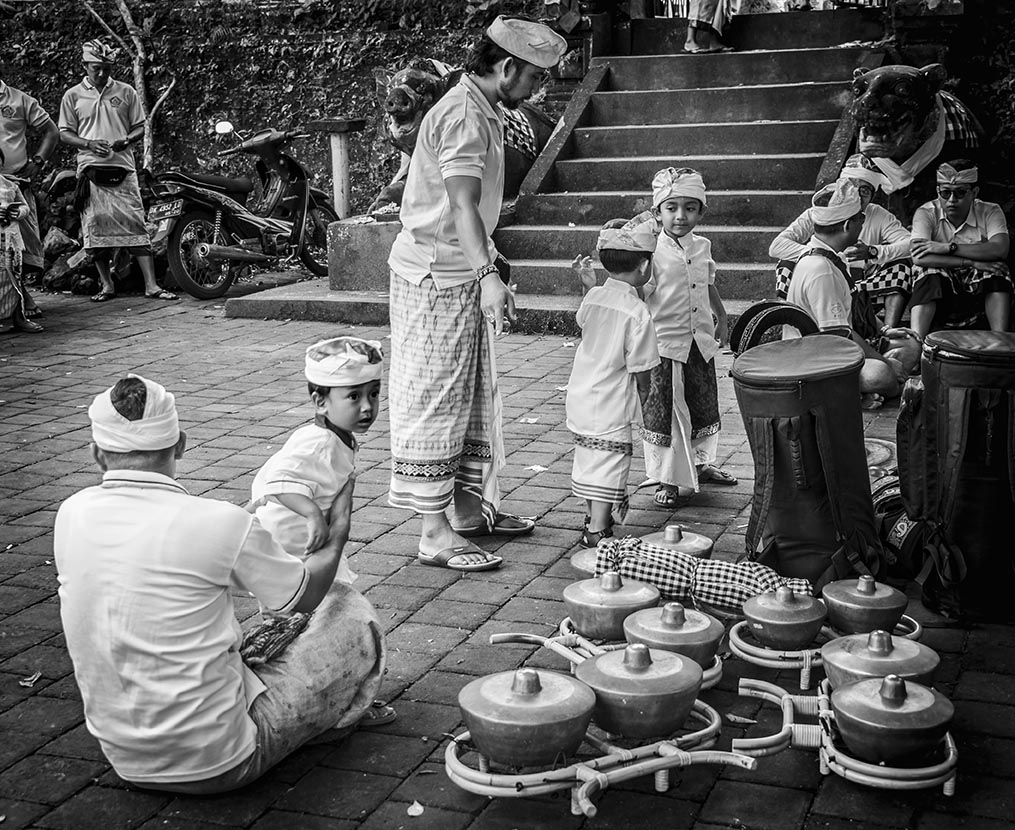
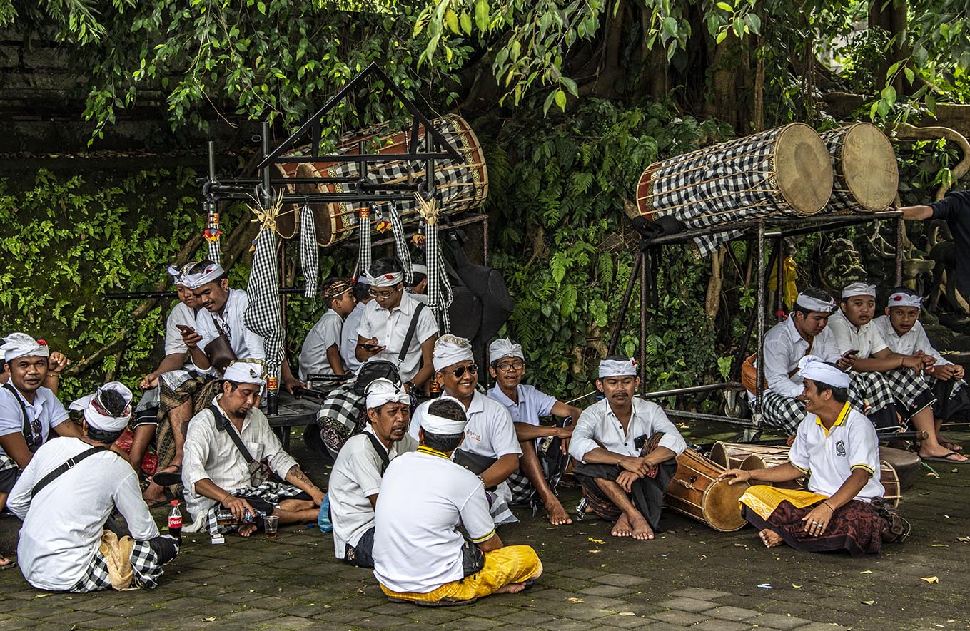
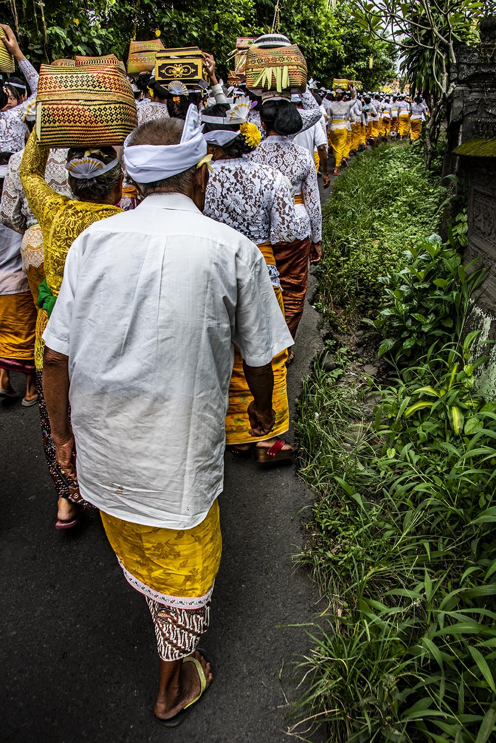
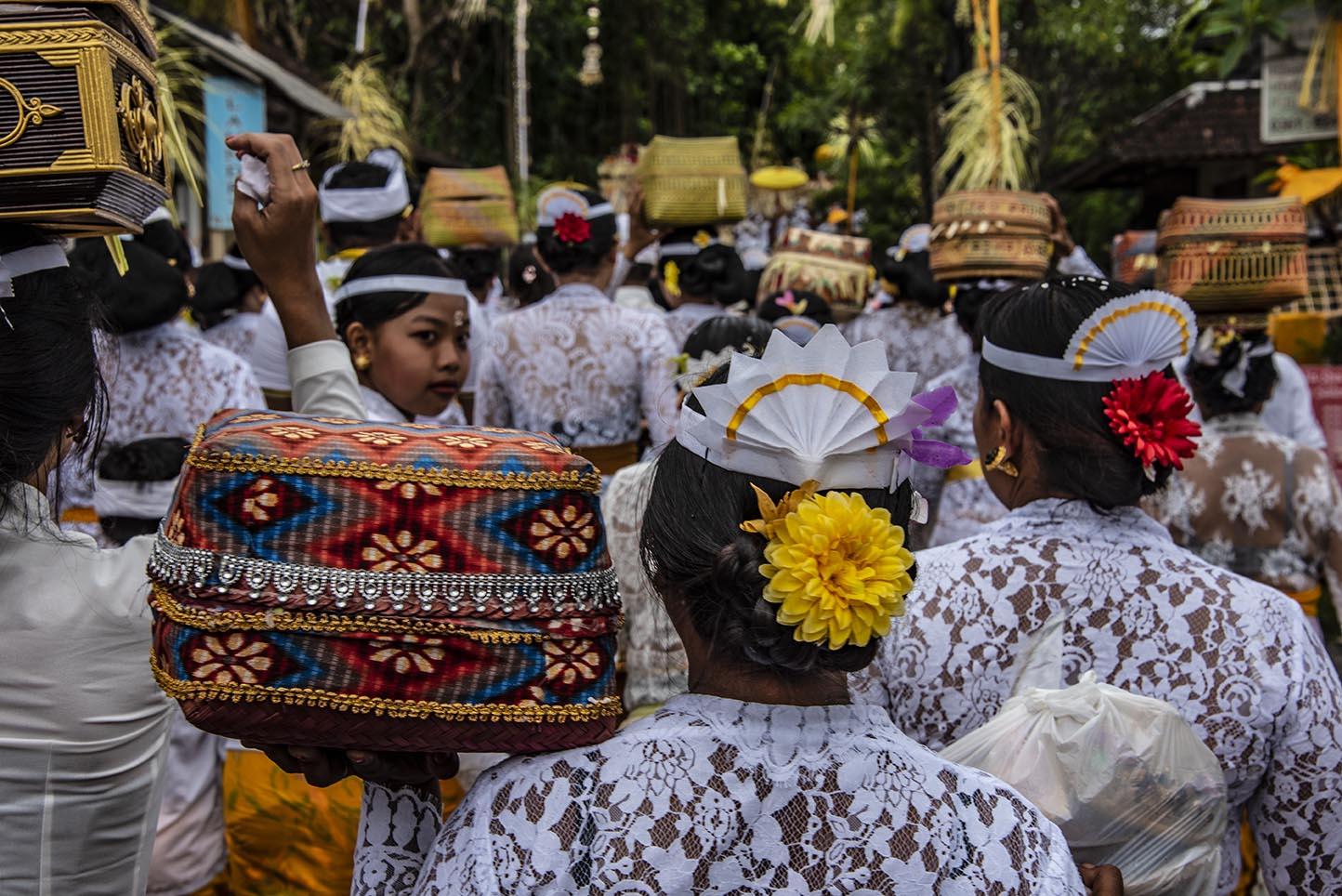
So I hung around outside with the parents with unruly children and the Balinese marching band (think gongs, conches for blowing, and lots and lots of drums.) Luckily, the Balinese are big on processions, because after what sounded from outside the walls like a lovely ceremony, the dignitaries left (would you believe it was the royal family of Ubud?) and were followed by a flood of people.

The procession begins! Photo copyright Karen Abrahamson.
Women with offerings. Photo copyright Karen Abrahamson.
And the men with their offerings. Photo copyright Karen Abrahamson.
And the requisite gongs. Photo copyright Karen Abrahamson.

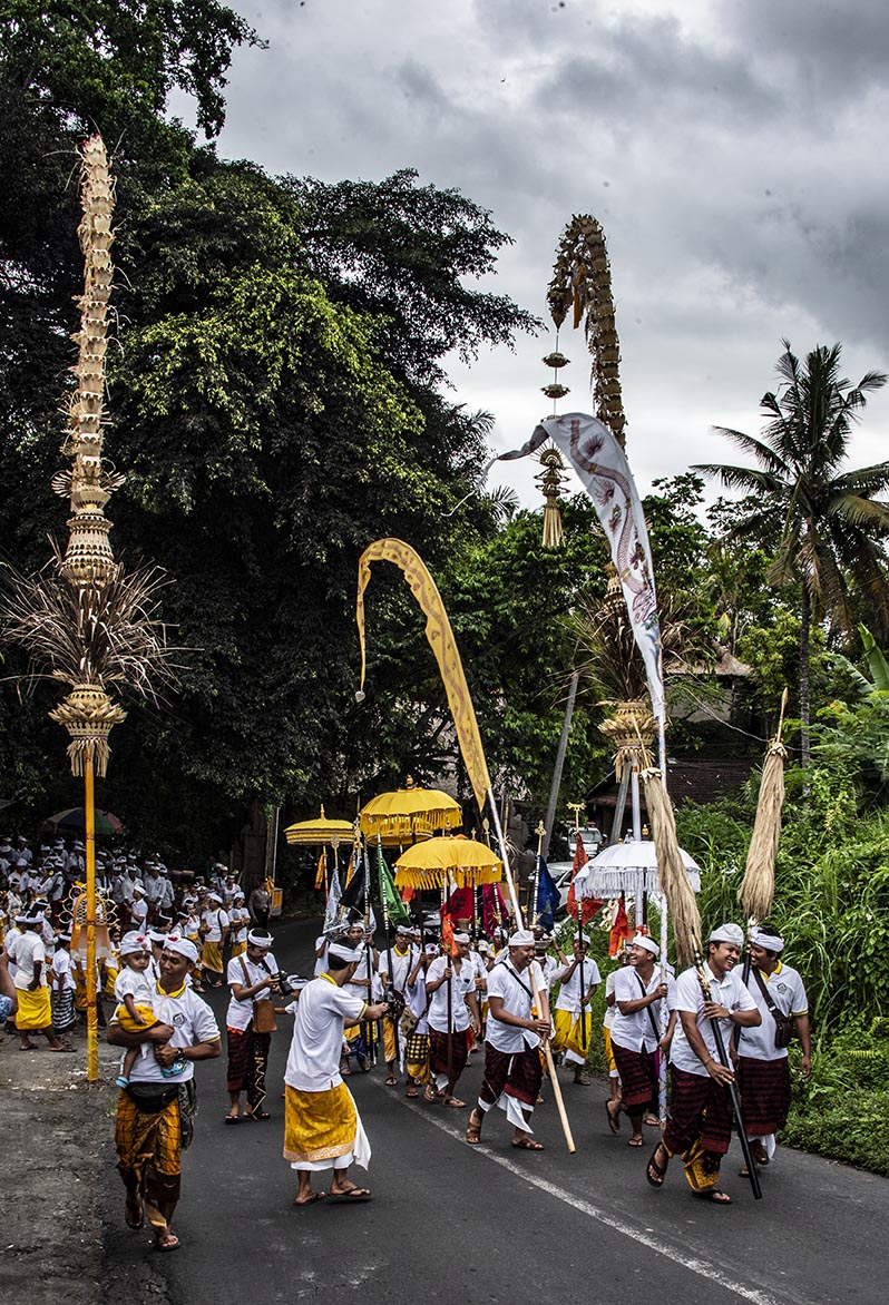
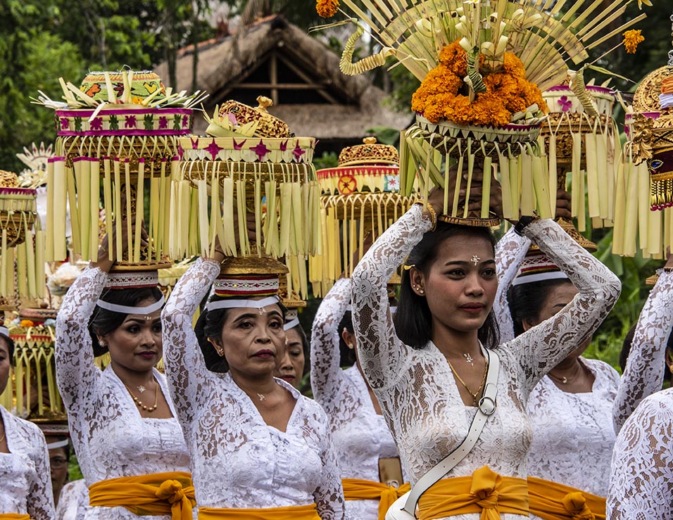
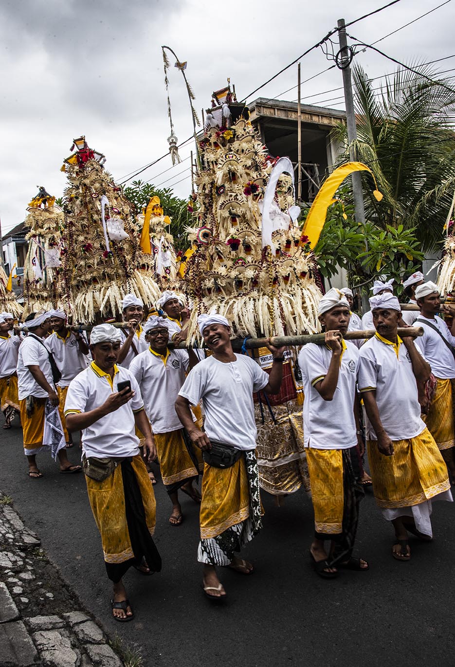
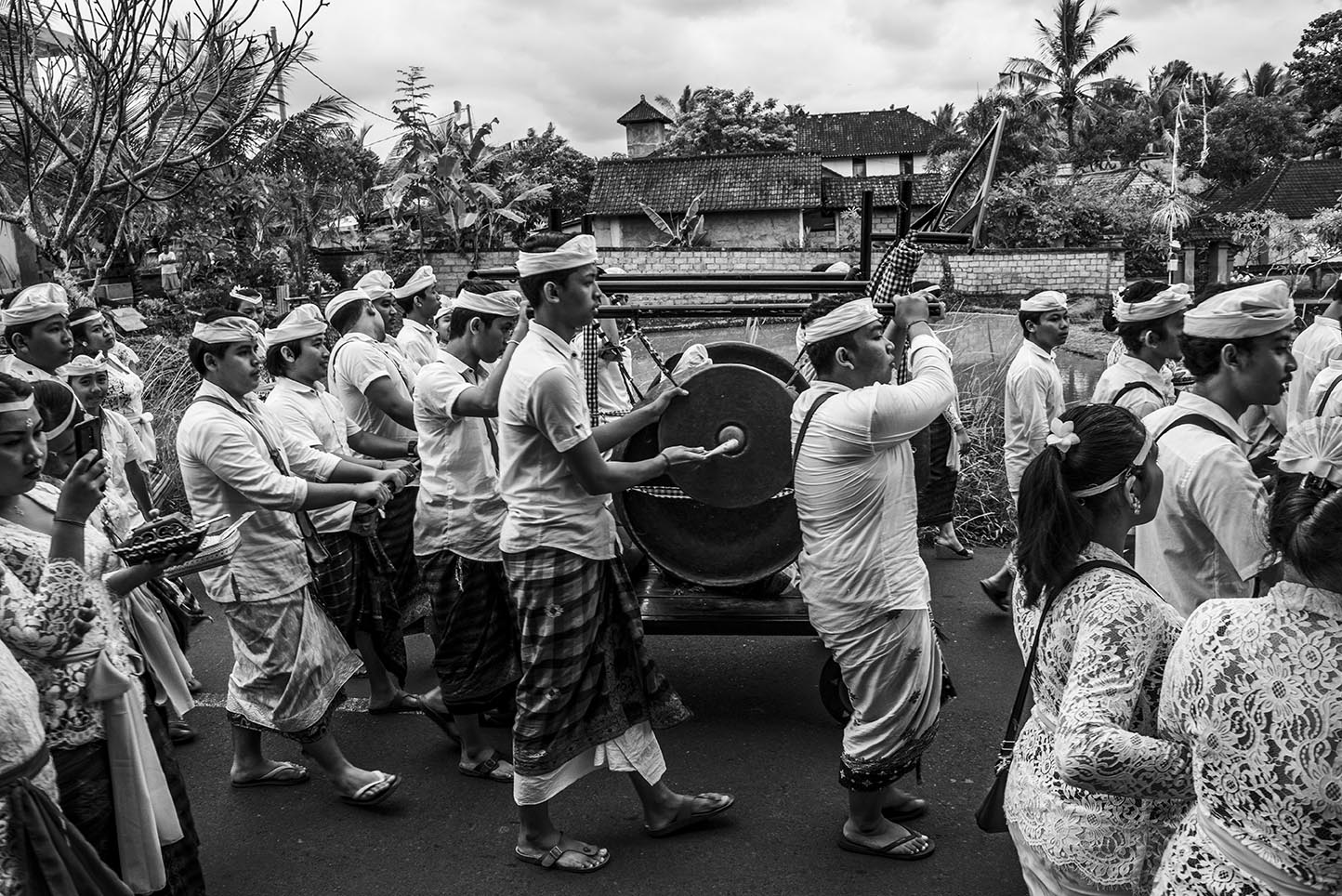
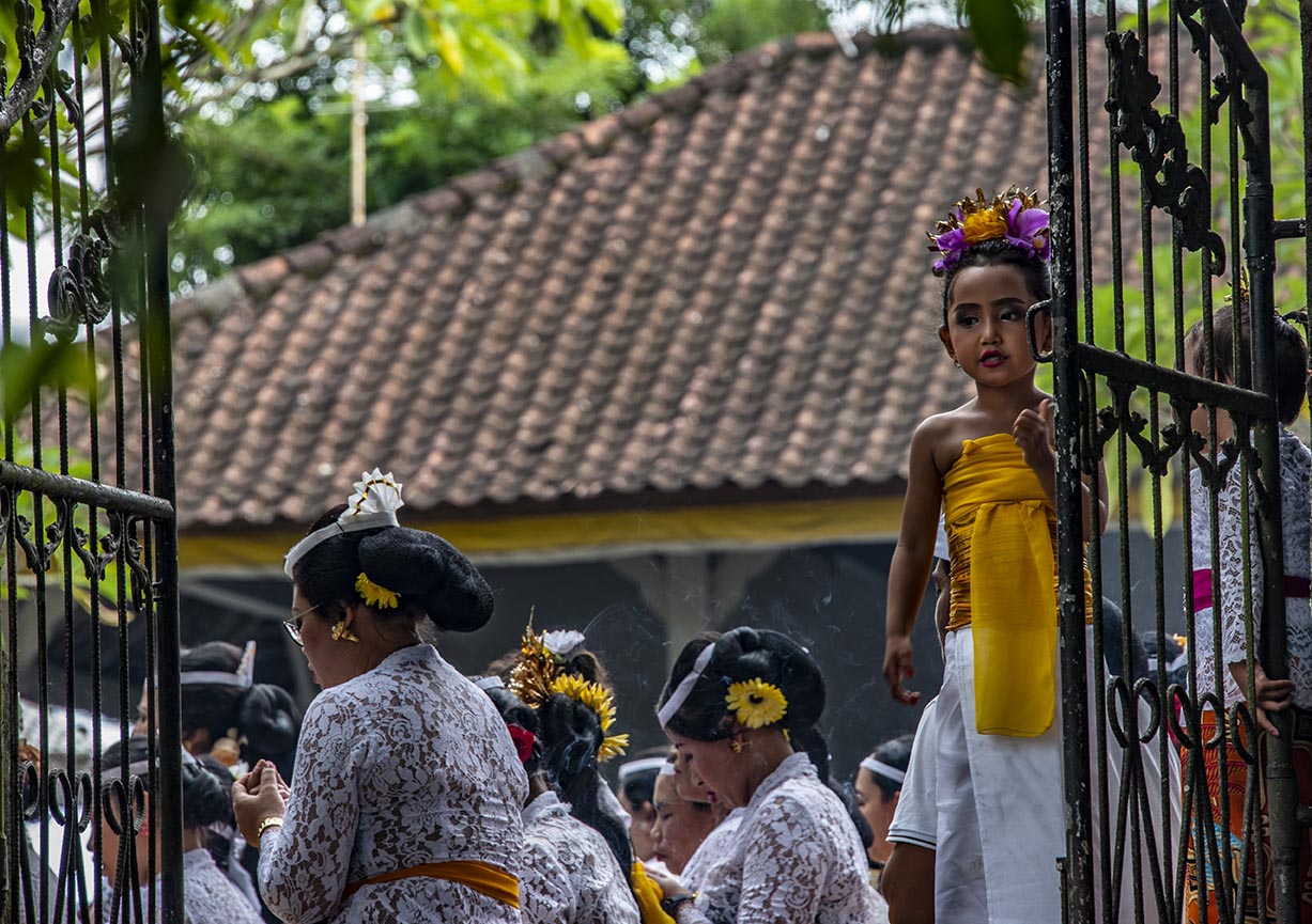
I ran up the road to get a better view and what followed was a village procession. The photos in this post tell the tale. A non-marching band. Children dressed up like princesses. Women carrying offerings on their heads and men carrying even larger offerings on platforms. And all the people in their finest sarongs and sashes. They marched up the road with so much laughter and friendship that I was swept along—until they reached another temple and I was shut out again.

The procession. Photo copyright Karen Abrahamson.

Darned no sarong.

And then I had to figure out how to get home…

From somewhere in Bali.

With offering boxes and flowers in their hair. Photo copyright Karen Abrahamson.

P.S.

(Yes, after realizing that my Whatsapp messages were being routed via North America so there was a time lag, I finally contacted my wonderful host by phone and he sent his son to rescue me. So I am no longer lost.)

Inspiration and a new Short Story

Inspiration and a new Short Story

I’m pleased to announce the publication of a romance novella called ‘The Rescue’. The story is based loosely on the fact that I broke my leg in January just like Amanda did in the story. The difference was, I fell on ice, not wet wood and I never had a handsome search and rescue man come and rescue me. Sigh.

I had to walk out.

I hope you enjoy the story. Here is the blurb:

The Rescue, by Karen L. McKee

Amanda Ripper escaped a controlling husband who convinced her that she was weak and an invalid. To convince herself that it wasn’t true, she fills her life with friends and hiking and refuses to become involved with anyone again. Then she falls and breaks her leg, reigniting the specter of her old life. Can a handsome man from search and rescue to give Amanda a chance at life again?

Available on Amazon, Smashwords and Kobo.

“A Good Traveler (or writer) has no Fixed Plans…”

“A Good Traveler (or writer) has no Fixed Plans…”

Porter on the Camino Inca. (2011) Photo (c) Karen Abrahamson

I purchased a lovely journal the other day. Though it’s not specifically a travel journal it certainly could be, because all of the quotes in the book relate to travelling, but when I read the complete quote by Lao-Tzu, all I could think of was its applicability to writing. The quote goes thus:

‘A good traveler has no fixed plans and is not intent on arriving.’

As someone who loves to travel, this quote provides a cautionary tale, because it warns that if you focus always on the destination you miss a lot along the way. Personally, I prefer to meander from place to place because you never know when you are going to find some better place to go than the place you intended. If you are always focused on heading somewhere, you have a much greater chance of missing where you are. As the Buddhists suggest, mindfulness of where we are, rather than worrying about the future  (or where we are going) brings much more happiness than the rush, rush, rush of hurried travel. It’s for that reason that I don’t take bus tours. The tours point out what they think you want to know, not what you can really learn just by being there.

Yukon path, (2008) Photo (c) Karen Abrahamson

But Lao-Tzu’s quote applies equally to writing. The writer who spends all his/her time solely focused on completing a project isn’t really giving themselves the opportunity to enjoy the project. I’m not saying that you should fool around and never finish, I’m suggesting that you should enjoy the process, no matter how difficult it is, and—just like the traveler who takes the time to meander you don’t need to be so end-driven that you can’t enjoy the little sidepaths that your muse sends you down.

I guess what I’m talking about is allowing the story to carry you along, just like the road can. You don’t have to know where you are going exactly, though you may have a vague idea that you would like things to end in a certain way. Some of my best days of writing are when I have allowed the story to carry me away from the story I had intended—those are the mornings I get up and rush to get writing again because I want to know what happens next. The funny thing is that if you allow the little digressions and flashes of insight to lead you, often the ending will turn out to be some place better than what you envisioned. Believe me, if the ending surprises you, it’s going to surprise and charm your reader, too.

So as a recovering ‘plotter’ of novels I think all novelist should allow themselves the freedom to step off the path they are following to explore the new world they’ve created. They might just find it’s bigger and better than they ever imagined.

Angkor Wat reflections. (2009) Photo (c) Karen Abrahamson
Danger-Maps, Belief and New Madrid

Danger-Maps, Belief and New Madrid

Schwedigon pagoda, Yangon, Myanmar
Schwedigon pagoda, Yangon, Myanmar (2000) Photo (c) Karen Abrahamson

Most of the maps I’ve written about over the past year have been maps setting out the geographic formations of the world—regardless of how skewed the map-maker might have made the map in order to influence the beliefs of others. But some maps are made to represent truth and to save populations from dangers, so today we’re going to look at a specific type of map—those used to convey earthquake danger. I’ve been researching this because it relates specifically to the current novel I am writing called Aftershock.

Most of us are familiar with California’s San Andreas fault, the 800 mile long fault that stretches northwest-southeast in California and that brings Los Angeles (west of the fault) two inches closer to San Francisco (east of the fault) each year. This much-talked about fault line has been the subject of disaster movies and books, and also of reams of geological research. The damage caused by the fault’s quakes led the State of California to have the San Andreas and other surface faults mapped and to require disclosure of proximity to fault lines in any residential real estate dealings in the state. The trouble is, that even though these maps are available, most people – even those who have lived in proximity to a faults line seem uninformed about the dangers and new buyers of homes are positively unaware of their proximity to faults even though they sign disclosures in their ‘offer to purchase’ agreements. Why? Because maps and the language around them can either be used to convey danger or to minimize it. In the case of the California real estate disclosures they say that the house is in the San Andreas zone, but they don’t specifically use the language ‘earthquake fault zone’.

Cypress knees and trees, Orlando (2012) Photo (c) Karean Abrahamson

Another example or earthquake danger maps, and one dear to my heart (given I live on the south coast of British Columbia, Canada), are the ones that show the Ring of Fire around the Pacific Ocean basin. Nothing brings home the dangerousness of the place I live as seeing the numerous dots presenting quakes over 4.0 magnitude in recent history around the Pacific. You see, there are so many dots that a thick black line extends around virtually all of the Pacific except for the stretch bordering the Antarctic and a small section of North America – the part of the coast where I live. Okay, so there hasn’t been a moderately sized quake here in the past 20-30 years (yes, Seattle has had one, but not here, so far). In fact there hasn’t been a really big one here in a heck of a lot longer than that. But historical evidence and that ring of dots around the ocean says that there’s a very good chance one will happen one of these days. Around here we grow up being told to be earthquake prepared. Are we? Given the number of schools that haven’t been seismically upgraded, I’d say ‘no’, even though the maps are there to show us the danger.

So why do we refuse to listen to the maps? A likely answer lays in another part of America. Right in the heartland of the U.S., where Missouri, Tennessee, Arkansas and Kentucky meet, in 1811/12 near the small community of New Madrid, a series of massive earthquakes (magnitude 7.5 and 8) wiped out entire fledgling towns, sent sand and water geysering into the air and lifted huge chunks of the landscape. The only thing that stopped huge loss of life was the fact that few people lived there.

Research into the quake says this type of quake will happen again. The trouble is the quake zone isn’t at the edge of a tectonic plate and there isn’t something like really a visible fault line to show where the quake will occur because these quakes occur far underground—that’s also why they are so devastating—and so life in the Midwest has mostly been focused on the danger of tornadoes, rather than the lurking danger right underfoot.

Sunrise over Porto, Portugal. (2005) Photo (c) Karen Abrahamson.

The trouble with this type of deep earthquake is that shockwaves travel farther and wreak more damage. In fact, geologists predict that such a quake today would be felt from Colorado to Washington D.C. and could wipe out most of the country’s central infrastructure.

As a result when, in 1990 a prominent inventor named Iben Browning predicted a major quake would occur in the New Madrid fault zone between December 1 and 5th of that year, the media promulgation of maps showing concentric areas of damage seriously impacting cities like St. Louis, Nashville, Birmingham, Little Rock, Jackson and Chicago started to get people taking the danger seriously. Children were kept home from school during the danger days. T.V. crews descended on the area like flies on road kill and everyone held their breath.

When nothing happened, of course finally people began to listen to the scientists who had previously laid out why the big one wasn’t likely to happen at that exact place and time. But the maps had done their damage. They’d laid out a ‘cartography of danger’ that hadn’t arisen. As a result, even though the states of Kentucky, Missouri, Arkansas and Tennessee try to prepare people for earthquakes because the risk of the big one still exists, they have an even more uphill battle than they do in California or here in the Pacific Northwest. You see, seeing a fault line on a map may not bring home the importance of believing, but when what you believe the danger presented on the map and then nothing happens, you’re less likely to believe in future danger.

So when the big one does hit, it will be Aftershock, indeed.

A pile of bricks is all that remains in earthquake-prone Peru. The ruins of Huaca Pucllana, Miraflores, Peru. (2011) Photo (c) Karen Abrahamson.


The Character of Canadian Cartographers

The Character of Canadian Cartographers

Alpine flowers, the Kane Lakes, B.C. (2012) Photo (c) Karen Abrahamson

In many of my map posts I’ve written of the unusual people who led the map making ventures, whether mystical Frau Mauro of Venice, the ancient Chinese voyager General Zheng He, or the dedicated native British East India Company surveyors who surveyed the Himalayas. Of course Europe and Britain and America have their own cartographic heroes, so I thought I’d take a few moments to mention a couple of religious cartographers who played a huge role in mapping Canada.

Jesuit Father Frencesco Bressani came to New France (Lower Canada) in 1641 as a missionary and with the express plan to measure astronomical eclipses in order to calculate longitude. At age 32, only a few years in-country, he was captured by Iroquois just outside Trois-Rivieres and was tortured, burned, beaten and mutilated for two months. Somehow he survived and was ransomed to the Dutch and returned to France. Regardless of his ordeal, he came back to New France the next year for four years before returning to Italy where, in 1657 he published his map, the Novae Franciae Accurata Delineatro.

This map, considered the rarest of Canadian maps, not only shows Native territory, but is most valued for its many illustrations. These give an astounding view of Native life as well as vivid drawings of the martyrdom of many missionaries, including being slashed with glowing bark, being placed in boiling water and being cut up alive. Dangerous work, cartography.  Of course the map comes with controversy. Was Bressani even able to draw, when his own letters indicate that his hands were so badly mutilated that he could no longer do mass properly? (One hand had only one finger left.) Historians believe the map was drawn by one Giovanni Frederico Pesca, in Italian engraver, working on Bressani’s insightful information.

Kane Lakes, (2012) Photo (c) Karen Abrahamson

The Jesuits like Bressani were responsible for much of the early mapping of Canada, but in the 1800’s the missions and religious mapping was assumed by the Religious Institute of the Oblates of Mary Immaculate. This order was founded in 1816 in Paris with the motto that meant Right to the ends of the Earth! and they lived up to this when they established their first mission in Canada in 1841 with a focus on Canada’s north along the Mackenzie River Valley. Long-bearded and black robed, the Oblate fathers became well known to the Natives, but none more so than Father Emile Petitot.

Petitot came to the Mackenzie River in 1862 only two weeks after he was ordained. He stayed for twelve years, most of the time travelling with Native companions through the uncharted north from Great Slave Lake to the Arctic Ocean and between the Mackenzie and Laird rivers. He made detailed observations of the Native communities, down to the condition of their teeth and the level of stammerers in specific populations. He learned much of the Native means of living including the guiding marks they placed on river channels to show which were open and which were dead ends. He made maps that set out geographic data of the interior of the northern basin, and discovered the Riviere a Ronciere-Le Noury—a river that geographers denied existed for eighty years, until aerial photography proved Petitot was right.

Quebec churchyard. (2005) Photo (c) Karen Abrahamson

Petitot’s maps made him something of a celebrity in Paris, Ottawa and London, but he was also watched closely by his superiors. Historians describe Petitot as something of an absent-minded dreamer who longed for long voyages, but who also was apt to freeze his fingers because he’d forget to wear his mittens. As well, his missionary duties went something by the wayside. He spoke native dialects fluently and was accepted by the Native groups he met, but he had some unfortunate predilections towards young native men and was excommunicated at one point. Mental illness also plagued him. He variously predicted the end of the world,  proclaimed his superior had murdered Jesus and the Virgin Mary, and could become erratic and violent. During these dark spells he would be tied down and placed under guard to stop him from running naked in the snow. It was not until 1882 that he was quietly placed in a Montreal mental hospital after which he returned to France for good.

Petitot’s departure ushered in an era where the religious orders were no longer so prominent in Canadian cartography. But their memory lives on in the ranks of Canada’s memorable cartographers: the devout, the brave, the mad.


The Star Raft: They came from the rising sun (part 2)

The Star Raft: They came from the rising sun (part 2)

Two weeks ago I wrote about the evidence showing contact between China and Africa long before the Portuguese sailed around the tip of Africa and into the Indian Ocean. More evidence of this appears from maps found in Korea and dating back to 1402 that show the WEST coast of Africa as far north as the Orange River, one of the longest rivers in Africa, which forms the international boundary between modern day South Africa and Namibia. This same map places Africa immediately opposite Indonesia with a string of small islands in between, suggesting that whoever drew the map, didn’t get there via India and the Gulf and down the African coast, but instead by sailing across the Indian Ocean. Records suggest some of these Chinese travelers came by way of a Star Raft. So who were these sailors and what is a Star Raft an how does this have relevance today?

Unlike later generations of Chinese dynasties, the Tang dynasty (A.D. 618-907) was outward looking and venturesome. This continued with the Southern Song Dynasty (A.D. 960-1279)who had lost half their territory to the Tartar hordes of the north. To make up for their property losses, they looked to oversees trade to fill their coffers and China became, for the first time, a maritime nation.

The ships they built had five or six decks, and carried a year’s supply of grain, herds of pigs and jars of fermenting wine. They carried the world’s most advanced seafaring technology in magnetic compasses, water-tight bulkheads, advanced rudder systems, sounding lines, and a sail designed for steering into the wind that could have allowed them to travel into the trade winds that had deterred the Arab seamen. By the end of the twelfth century they were on the edge of the western Indian Ocean and had appeared in the Gulf and off Yemen.

Old woman and Brazier and Xi'an Temple (1998) Photo (c) Karen Abrahamson

While many of these huge boats went no farther than India to trade, accounts from those few who went further also made their way back to China and described the port towns and the people they met. They describe the sources of ivory and rhinoceros horn, of frankincense, ambergris and a red gum resin called ‘dragon’s blood’ as a series of villages down the East African coast. News also came of the landscape and the African wildlife, including the marvelous creature called a camel-ox with a hide like a leopard’s, the hooves of a cow, no hump but a neck nine feet long perched above a body ten feet tall.

The contact between Africa and China continued, including embassies of African traders to the Chinese court. Proof of this comes both from Chinese records and from the diaries of Ibn Battuta, the many travelled Arab who wrote of meeting a man from Mogadishu who had been in China.

With the fall of the Song Dynasty and the coming of the Mongol hordes, the naval trade reduced, but the rise of the Ming Dynasty (A.D. 1368-1644) saw the creation of a huge maritime fleet that in 1414 sailed into the western Indian Ocean led by General Zheng He, Grand Eunuch of the Three Treasures. (See my short story here.) Zheng He was the Chinese Columbus, but the Chinese ships topped Columbus’s ships in every way. While Columbus sailed with three ships with single decks, Zheng He sailed with sixty-two galleons that each outweighed Columbus’s ships three to one. While Columbus had about 100 men, Zheng He had 868 civil officers, 93 commanders and 26,800 soldiers plus numerous others.

But unlike Columbus, who was a man of exploration, Zheng He led a Star Raft – an expedition planned to bring the ‘star-like radiance of the imperial ambassador’ and to win allegiance of distant people for the Chinese emperor. Yes, goods were traded during these voyages, but the symbolism of the exchange was unique to the Chinese. They believed that their trading partners were paying homage to the Chinese sovereign of the world. So unlike Columbus. the Chinese venture was based in looking inward – bringing the homage of other places to the center of the world.

Inside a modern Xi'an Temple (1998) Photo (c) Karen Abrahamson

Which makes me wonder about the state of the world’s economy today as China’s economic engine begins to overtake that of the United States. Are we watching a modern-day version of the Star Raft as western companies and governments seek their trade accords with the new China?


They Came From the Rising Sun

They Came From the Rising Sun

A Portuguese ship off the Algarve. Photo (c) Karen Abrahamson

I’ve spent much of this blog writing about the great European mapmaking tradition and the exploration that went with it, but long before European Kings considered funding a certain wild venture to reach India and China by sailing west across the Atlantic, and long before Vasco de Gama sailed round the Cape of Africa and into the Indian Ocean, the Chinese were venturing westward, too. They sailed from Canton and through the Malay straight and into the Indian Ocean. They mapped it, too.

Chinese records indicate that trade between China and Africa began as early as the Han Dynasty (202 BC to AD 220). Two of Africa’s most powerful nations of the time, Kush and Axum had trade relationships through intermediaries. In Kush the remains of ancient pottery and bronze utensils indicate that they may have been copying the styles of the Chinese goods being brought to its ports by Arab traders. Axum may have been the source of the rhinoceros horn, ivory and tortoise shell that Roman traders took to China in AD166.

But this was trade by intermediary, not face to face trade. The first trade by Chinese with African is thought to have occurred not much later, but it probably didn’t occur on African shores. Accounts of ancient travelers indicate that in places like Ceylon merchants and sailors from as far afield as China, Persia, Homerite countries and Adulis (an African port city) came together to trade. One Chinese trader, Fa Xian, stayed in Ceylon for two years before returning home to write his accounts of the people he met.

Dhow off Zanzibar Island (1994) Photo (c) Karen Abrahamson

During the time of the Tang Dynasty (618-907) records show that a Chinese did set foot on African soil. Du Huan, was a Chinese military officer who was captured by the Arabs during conflicts near Samarkand. After spending twelve years in the Abbasid Empire, he reappeared and wrote a record of his travels. Of the bits of that memoir that have been preserved over the ages, he speaks of travelling south over a great desert to the land of the black people, where there was little grain and no vegetation and malaria was endemic. Researchers today think this was probably modern-day Eritrea.

A Chinese junk from the 1270s was discovered in Guangzhou harbor in 1974 with cargo such as tortoiseshell, frankincense and ambergris that strongly suggest trade with Africa. Between 800 and 1400 Chinese goods were also making their way to Africa so that Chinese porcelain became common as decorations on houses and mosques and broken porcelain still apparently litters East African beaches. Chinese coins from the Tang Dynasty (the kind with the square hole in the middle) have been found along the coast and on islands like the Bajun and Zanzibar.

Chinese tower, Xi'an, China (1998) Photo (c) Karen Abrahamson

Of course, the Chinese travelers to these distant shores in these early days weren’t representatives of the Chinese dynasties. No they were merchants and traders. Most of these went as far as India and no farther and were content to trade with the middlemen who brought goods from Africa. But a few travelled further and the routes were known in the Kingdom of Heaven. In the ninth century the Tang Prime Minister and geographer, Jia Dan, knew of the sailing routes that gave 90 days from Canton to Arabia and 20 days for a further voyage southwest to a country called Sanlan.

Cyclist on the western Zanzibar beach. (1994) Photo (c) Karen Abrahamson

Of course, if the Chinese were anything like the later Portuguese, this information could have come from Arab sailors as a result of the government confiscating all maps from visiting sailors, but a map compiled between 1311 and 1320 by the Chinese cartographer Zhu Siben clearly shows the triangular southwest pointing African continent at a time when the western world thought that Africa didn’t end, but instead the landmass continued on eastward before joining the mainland again and enclosing the Indian Ocean as a great inland sea.

Just think of what this map suggests: The Chinese were there first. If they had kept going, they could have discovered Europe long before the Europeans ‘discovered’ the route to China.


The Lure of Venturing into the Unknown

The Lure of Venturing into the Unknown

Himalaya Monastery outpost (2000) Photo (c) Karen Abrahamson

The other day I was reminded of something that seems intrinsic to human beings—the need to go where no one has gone before, to discover and map and mark our presence upon the world whether it be by having a place named after us, or by hammering a flag into a mountain top. What reminded me of this phenomenon, was the unending effort of one of my cats.

You see, in my house I have a cupboard that holds my washer and dryer. Above that cupboard is a nine-foot high display ledge that holds three large terra cotta pots and an antique Burmese carriage carving safely out of the way of the carnage of scampering little cat hooves.  My cat, Ben, has known of the shelf. In my arms when we walked past he always strained upwards like a person wishing for wings, but there was no way up.

Or so I thought. I underestimated the lure of adventure into unknown worlds, and the too-keen intelligence in my cat when it comes to reaching the Promised Land. You see, unbeknownst to me, Ben has secretly been in training.

'The boys' watching their first snowfall
'The boys' watching their first snowfall. Photo (c) Karen Abrahamson

Over the past few years he has taken to leaping to the tops of doors and balancing. Over the past few months his training shifted to opening every bifold door in the house, including the one to the washer and dryer. Then, recently, he trained at climbing, and took it upon himself to open my linen closet, climb up the shelves and then climb out the small little ‘V’ of open space at the top of the bifold closet doors. Once there, he’d balance. Shocked the heck out of me the first time I walked in and didn’t see him until he leapt down in front of me.

I’m sure you can see where this is going.

After years of training, much like a mountain climber trains before attempting Mount Everest, or those surveyors before tackling mapping a mountain range, while I was away at Disney World, Ben tackled his adventure.

The result? One smashed terra cotta pot and a cat with a very big smile on his face.

Since I’ve been home he has shown me how he climbs his mountain. Then he sits on the ledge far above my head and meows his accomplishment—until I grab a chair and haul him down. He seems satisfied with himself and content. When I carry him past the ledge he no longer looks up at the Promised Land. After all, he’s been there, and until I can figure out how to lock the door he can get up there any time he wants

So I guess, just like the explorers of old, I’m going to have to find a way to commemorate what he’s accomplished. Guess I’ll dub his ‘Everest’  ‘Benares’ Ledge’.

And cat-proof the remaining terra cotta pots, of course.

Ben. Photo (c) Karen Abrahamson


Book 2 of the Terra Trilogy is now available!

Book 2 of the Terra Trilogy is now available!

I’m thrilled to announce that book two of the Terra Trilogy is now available in e-book and the print publication will be available in May.

In the years after the ‘Big One’ destroyed most of human civilization, a lone city perches precariously on the Pacific Northwest coast of North America.

When nomadic marauders attack the Independent city of Couver, seventeen-year-old Terra Vargas must choose: use her Cartos powers to protect her city, or rescue her mother from the marauders’ camp. But as her control over the earth power erodes, so does her ability to choose wisely.

Stay or go?

Either way, there will be a horrible price to pay.

Available on Amazon and at Smashwords and other fine e-tailers.


Faith, Maps and Portolan Charts

Faith, Maps and Portolan Charts

Okay, I’m anachronism. It’s Easter Sunday and so I’m writing about faith—well, a little bit of faith—faith and maps.

As I’ve said, I like maps and will continue to use them. Though many people are turning more and more to GPS systems in their vehicles, I still have my trusty book of street maps of the metropolitan area where I live. When I pull out my yellowing, dog-eared map book I’m reminded of the volumes of Portolan charts of old, that were the predecessors of the Mercator projection I spoke of HERE.

Portolan charts were mariner charts, used by sailors to navigate the Mediterranean and then the coasts of Africa and Asia. The earliest existing portolan chart dates from 1290, but records as early as 1270 talk of a captain pulling out charts to convince a frightened king that their ship really could reach land during a terrible storm. Portolan charts have distinctive features, most noticeably the rhumb lines and compass roses that gave sailors bearings to set their sailing headings. These rhumb lines set out the four cardinal directions and the principle wind directions (North, Northeast, East, Southeast, South, Southwest, West and Northwest) as well as the eight half-winds (NNE, ENE, etc.) Portolan maps also had detailed, careful place names along the coast, color coding of places to show importance, and standard ways of showing rocks and shoals, while overemphasizing bays and headlands—all important information for sailors trying to reach safe harbor. This is very different from the predecessor of the Portolan, the medieval mappamundi , which generally had East at the top, and Jerusalem at the centre without any detail. The mappamundi were there to represent a way of thinking for the faithful; all they really needed to know was the location of Jerusalem in relation to where they lived. By contrast, the portolan set out in detail the way to make your way in the world.

Yes, there were issues with the portolan charts. They used a rough scale, but had none of the accuracy the Mercator Projection provided. Still, they served their purpose.

No one knows who made the first portolan chart, but researchers have shown that those we know about were copied, some by tracing (they can tell by small pinpricks left in the vellum, and some by simple eyeballing). Portolan charts were also generally written on vellum—sheep or calf skin prepared in such a way that the narrow end of the beast (toward the neck) could fit the narrowing of the Mediterranean. The vellum could handle the rigors of sailing better than paper could and vellum could role up for easy storage or could be made into volumes of portolan charts. Of course, because they had different makers, different parts of the world were drawn using different scales which made it a challenge to draw up larger maps of the world.

But portolan fell out of use with the advent of the Mercator Projection because, while the portolan charts were good for the Mediterranean and coastal shorelines, they were not as good for great sea voyages where the Mercator Projection provided relatively easy ways to chart a route from places like South Africa to New York.

So the beautiful, utilitarian portolan chart fell out of use, just like my map book has fallen out of favor in comparison to those tiny black box GPS units and smart phones that help gadget users to get from point A to point B. To me, it feels like civilization has taken a great leap forward by stepping back. No longer are we worried about great sea voyages (Mercator maps), or even the details of where such and such a place sits along the coast in relation to where we are (Portolan charts). Now we simply input our destination and trust the GPS to tell us which headings to take, much like medieval civilization trusted their priests to tell them how to live in relation to Jerusalem. Which makes me wonder whether we might have stepped right back to the days of the mappamundi, where our sense of direction is directly related to our faith—but today it’s our faith in technology.

The Easter Procession in Cuzco, Peru. Flower petals are thrown whihc have, over time, stained the Christ figure black. (2010) Photo (c) Karen Abrahamson


Recent Fantasy

Available HERE,

$1.99

Available HERE,
$3.99

Available HERE $1.99


Recent Mystery


Available HERE
$4.99


Available HERE,

$4.99


Available HERE,

$4.99


Available HERE,
$4.99


Recent Romance

Available HERE, $2.99